Software
QWET
QWET is an open source QGIS plugin for application and user adaptation of the Water Ecosystems Tool (WET). The QWET installer and the QWET source code is available through Gitlab: https://gitlab.com/wateritech-public/waterecosystemstool/qwet-installer
Development log
QWET 3.4.1 (22. Feb 2022)
Version 3.4.1 Updated to provide full support for Python 3.9.5, hence the Latest Stable Release of QGIS (version 3.16.16)
- Minor updates of the QWET Check to make it ready for a major release in pipeline. Hence most functionality of the QWET Check is for developer testing.
- Fixing issues with a minor Python error while un-ticking the QWET plugin.
QWET 3.4.0 (06. Jan 2022)
Version 3.4.0 featuring a new Diagnostics plot to support calibration assessments
QWET 3.3.0 for QGIS3.16.x (26 Nov. 2021)
New release version (3.3.0). Upgraded to support the QGIS 3.16.x stable release version. The new QWET features:
- A Calibration Helper Tool to assist users in application of an auto-calibration module.
- The skeleton for a QWET Check Tool. The QWET Check Tool will be finalized in a future version of QWET
QWET 3.0.0 for QGIS3 (07 Feb. 2020)
- Completely new version of QWET (formerly known as WET), which now runs in QGIS3 64 bit.
- QWET includes a compiled executable of the latest GOTM (physical) and WET (biogeochemical) codes.
- See information on biogeochemical code changes in WET (formerly known as FABM-PCLake) below.
Note that QWET is not backwards compatible. You must therefore create a new project to be able to run the model.
WET 1.3.5 (9. Sep. 2018)
- Updates to the conversion of SWAT to WET - fixing errors and speed.
- Updated routine to avoid automatic terminal closing when running the model. This allows the user to view debug advises from the GOTM domain if the model does not run properly.
- Implementing profile plotting. As the obs tab is still under development, the functions to support profiles are not fully operational, but please use it and report back on any issues.
To upgrade from WET 1.3.4 to WET 1.3.5 simply install (overwrite with) WET 1.3.5 from the .exe file. Starting from version 1.3.3 WET is compiled with netCDF4 so there is no longer any required updates of the QGIS python library. You may contact us and we will try to assist you with a project update. If you have existing projects from an earlier version of WET it is suggested to setup the project from scratch in WET 13.5 to fully unlock new features.
WET 1.3.4 (31. May 2018)
- Minor updates on interface to the clean-up toolbar.
- Updated user message regarding the pre-installed netCDF4.
If you upgrade from WET 1.3.2 to WET 1.3.4 directly, it is suggested to re-install your QGIS application and then install WET 1.3.4 from the .exe file. Starting from version 1.3.3 WET is compiled with netCDF4 so there is no longer any required updates of the QGIS python library. You may contact us and we will try to assist you with a project update.
WET 1.3.3 (28. May 2018)
- Updated with pre-installed netCDF4 - no need for updating the Python packages anymore.
- Updated with stable plotting function which handles matplotlib errors.
- Updated statistical calculations in comparison of simulations and observations.
To upgrade from WET 1.3.2 to WET 1.3.3 it is suggested to re-install your QGIS application and then install WET 1.3.3 from the .exe file. WET 1.3.3 is now compiled with netCDF4 so there is no longer any required updates of the QGIS python library. You may contact us and we will try to assist you with a project update.
WET 1.3.2 (5. Apr. 2018)
- Updated scenario tool to handle formatting of model files across text editors.
- Other minor updates.
To upgrade from WET 1.3.1 to WET 1.3.2 simply install WET 1.3.2. You may contact us and we will try to assist you with a project update.
WET 1.3.1 (19. JAN. 2018)
- Improved plotting functionality for obs vs. simulation regarding warmup period etc.
- From the updated core model executable (code version from 21. Nov. 2017) a linkage file was skipped in WET version 1.3, but the file is now included in version 1.3.1.
- Other minor updates.
To upgrade from WET 1.3 to WET 1.3.1 simply install WET 1.3.1. Older WET projects may still be run in WET 1.3.1, but to activate updates (the linkage file) you need to create a new WET 1.3.1 project for your study case. Alternatively you may contact us and we will try to assist you with a project update.
WET 1.3 (20. Dec. 2017)
- Fixed issues with deleting scenarios.
- Better check of python dependencies to allow limited usage.
- Enabling depth range plotting for visualization of observations vs. simulations.
- Integrating compatibilities for matplotlib with newer versions of QGIS.
- Fixing issues with problems when using long decimals for parameters.
- Updated core model executable (code version from 21. Nov. 2017) and corresponding parameter files.
- Other minor updates.
To upgrade from WET 1.2 to WET 1.3 simply install WET 1.3. Older WET projects may still be run in WET 1.3, but to activate updates in the core model you need to create a new WET 1.3 project for your study case. Alternatively you may contact us and we will try to assist you with a project update.
WET 1.2 (3. Nov. 2017)
- Fixing issues with auto-generated simulation ranges.
- Implementing user-info when viewing observations vs. simulations.
- Minor interface updates.
- Other minor fixes and updates.
To upgrade from WET 1.1 to WET 1.2 simply install WET1.2 and open your existing WET project.
Let us know if you run into problems.
WET 1.1 (9. Oct. 2017)
- Updated to match the new FABM-PCLake core code (e.g. additional fractions of nutrients, 9. Oct. 2017).
- Fixed issues to support high DPI screens with a semi-adaptive layout.
- New tab implemented where observations may be added and compared to simulated output.
- Fix of minor bugs.
- Updated references in the "about" tab.
WET
WET is the aquatic ecosystem engine of QWET, and describes interactions between multiple trophic levels, including piscivorous, zooplanktivorous and benthivorous fish, zooplankton, zoobenthos, phytoplankton and rooted macrophytes. The ecosystem model also accounts for oxygen dynamics and a fully closed nutrient cycle for nitrogen and phosphorus. An executable of the coupled one-dimensional hydrodynamic-ecosystem model GOTM-WET is part of the QWET installation package for QGIS3.
The complete (fortran) source code for WET is also available through Gitlab: https://gitlab.com/WET
To download the source code, you first need to set up a (free) Gitlab account. Please read the download instructions for more information.
Development log
(07 Feb. 2020)
BREAKING: this date marks the release of WET! WET is a new generation ecosystem code that is based on FABM-PCLake. FABM-PCLake is no longer actively developed - all new developments will be based on WET. Compared to the original PCLake model, several major advances have been included in the new WET code, including:
- Ability to integrate thermo- and hydrodynamics through coupling to physical models via FABM (e.g. the 1D GOTM and the 3D GETM)
- Shear-driven resuspension option inspired from CAEDYM
- Complete modularization of code, meaning that users can now configure any number of phytoplankton groups, zooplankton groups, fish and macrophytes
- Modifications to, and additional, light functions so model may be applied for both southern and northern hemisphere locations (without further need for modifications).
- Implementation of multiple organic fractions (now including both particulate and dissolved fractions)
- Implementation of the foraging arena theory inspired from Ecopath/Ecosim for interactions between predators and prey
- Implementation of nitrogen-fixation options for phytoplankton inspired from CAEDYM
- Implementation of vertical mobility functions for phytoplankton, zooplankton and fish
(22. Oct. 2018)
- Fixed minor bug relating to calculation of sediment oxygen demand.
- Changed half-saturation expression for juvenile fish predation dependency on zooplankton conc. from benthic to pelagic form.
- Added diagnostic output for macrophyte coverage.
(21. Nov. 2017)
- Code clean-up including removal of redundant code.
- Fixed bug relating to the maturing of juvenile fish.
- Fixed bug relating to light function for cyanobacteria.
- Added diagnostic output for oxic-layer fraction in sediment.
(9. Oct. 2017)
- General clean of code and removal of minor bugs.
- Implementation of an additional nutrient fraction to distinguish between dissolved and particulate organic nutrients in both the pelagic and benthic domain.
- Updated parameter naming of default values for settling and sedimentation rates.
Developments
QWET and WET are continuously being developed, to account for new discoveries within aquatic ecosystem functioning, to enable simulations of new relevant management interventions and also for outputting key diagnostics of ecosystem health. The ongoing development of QWET and WET is dependent on incoming projects. If you have ideas for further developments these can be posted on the “Issues board” of the Gitlab page of WET (using the issue label “ideas”).
Examples of potential new developments to QWET include:
- Enhanced use of the various functionalities available in QGIS. For instance allowing users to draw inlets, outlets, monitoring stations on the map canvas and subsequently configuration in the GUI of WET.
- Incorporation of greater flexibility for the user in configuration of number of inflows/outflows and evaporation calculations.
- Implementation of sensitivity analysis and auto-calibration tools to support model application and adaptation for a specific aquatic system.
- Wider flexibility regarding configuration of the core aquatic model where users may choose among different varieties of models already developed and published, which may prove better for a specific system.
- A feature for analyzing past climate data and processing that to simulate into the near future (e.g., 10-20 years), e.g., for simulating the resilience and temporal response lag of an ecosystem after a management intervention.
- A feature for exporting a standard report of a QWET application (e.g., exporting a standardized pdf report based on the user-adapted QWET application).
- Additional management interventions, including harvesting or transplanting of rooted macrophytes, sediment dredging, oxygenation and mineral dosing of P-binding agents.
- Functionality within QWET to enable selection, download and formatting of ECMWF meteorological time series for any location in the world.
Examples of potential new developments to WET include:
- Several of the potentially new functionalities of QWET, as listed above, will require some further development of the WET fortran code, including, for example, descriptions of processes and state variables involved during dosing of a P-binding agent.
- A new module for simulating key green-house gas emission dynamics.
- More explicit behavior of fish (e.g., a new IBM-based fish module).
Related software
QGIS
- QWET is implemented in the open source QGIS3 (www.qgis.org). We recommend using the long-term stable release of QGIS3 64 bit.
GOTM
- The General Ocean Turbulence Model (GOTM) is a one-dimensional hydrodynamic model, developed by an international community of scientists. GOTM is open source, and the source code is available through Github: https://github.com/gotm-model/code. Further information on GOTM is available through http://gotm.net.
FABM
- The Framework for Aquatic Biogeochemical Models (FABM) enables coupling between several hydrodynamic and biogeochemical models, and was developed by Bolding and Bruggeman ApS. FABM is open source, and the source code and further information is available through Github: http://github.com/fabm-model/fabm/.
QSWAT
- Simulations in QWET can read output from the QSWAT model, which is an eco-hydrological model that describes processes in a watershed. QSWAT is open source, and is available for download here: http://swat.tamu.edu/software/qswat/.
PyNcView
- PyNcView is a NetCDF viewer written in Python. It provides a graphical user interface for creating animations and publication-quality figures. PyNcView is open source, and the source code is available on Github: https://github.com/BoldingBruggeman/pyncview.
- A Windows installer is available on Github: https://github.com/BoldingBruggeman/pyncview/releases or here.
SWAT2lake
SWAT2lake is a tool to assist in the delineation of lake or reservoir watersheds with QSWAT. The tool, intended to work in parallel with QSWAT, allows the user to delineate a watershed that is tailored to the waterbody outline, thus accounting for the entire drainage area flowing into it. This capability covers an existent gap when modelling lakes and reservoirs watershed with SWAT.
Download instructions
To download the SWAT2lake installation package, you must first register a free Gitlab account. When signing into the SWAT2lake Gitlab page, you will get access to the software, an "Issues" board (effectively a discussion and user support forum) and wikis.
We have prepared a short instructional video on how to register a Gitlab account, and then downloading and installing WET, the procedure for SWAT2lake is fully equivalent to the procedure for downloading WET.
Why do you need to register to access SWAT2lake?
SWAT2lake are free, open source, software packages. However, in order for the developer team at Aarhus University to have internal support for offering ongoing maintenance and future improvements, we need to demonstrate the strength and impact of the software tools through the collection of some basic information on how many is using the software.
GIS-based shadow cast framework for lakes and reservoirs
GIS-based shadow cast framework for lakes and reservoirs is a Python-based framework for analyzing and quantifying potential shadow casts on lake and reservoir surfaces from the surrounding terrain features. The framework was developed for application to a Danish lake experimental facility, but may be used for lakes or reservoirs world-wide to bring forward if shadow casts are to be considered and accounted for in modelling studies by correction of e.g. radiation inputs.
User guide
soon to be completed
Download instructions
please contact by email: an@bios.au.dk
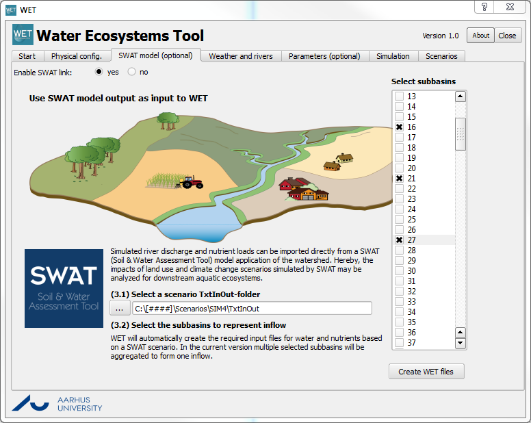
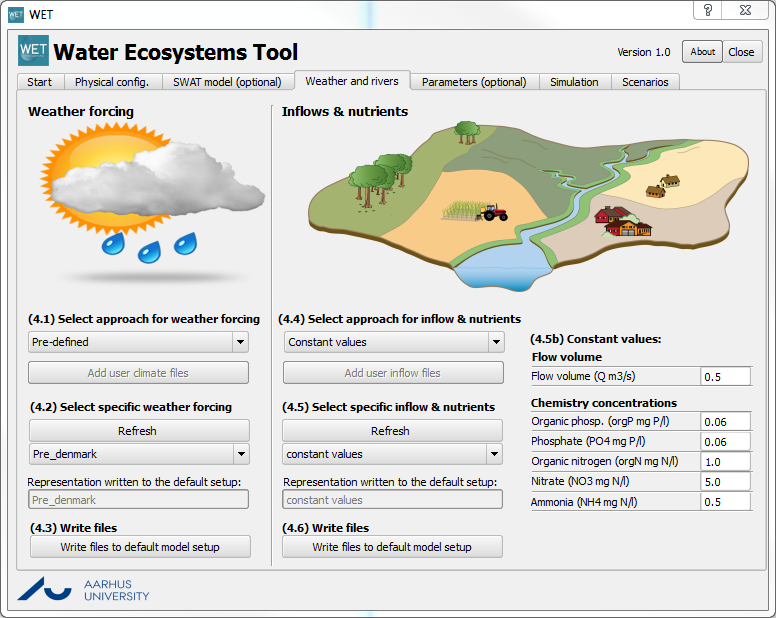

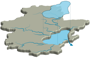
Screenshots of WET.

Potential developments to WET include simulation of additional management interventions, such as P-binding agents as applied here to Lake Okaro, New Zealand.
Photos: WET-team