Cases
Lake Hinge
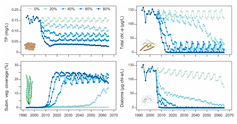
Lake Hinge is a small, shallow lake with max depth of 2.6 m and a surface area of 0.91 km2. The lake has a low hydraulic retention time (between 2 to 4 weeks) and is located in a catchment dominated by agriculture. In the last twenty years, the lake has experienced improved water quality conditions. The hydrodynamic-lake ecosystem model, GOTM-FABM-PCLake (now called GOTM-WET), was applied to Lake Hinge to investigate the effects of nutrient load reductions. First, the model was calibrated and validated against a comprehensive dataset covering 14 years of observations including temperature, inorganic and organic nitrogen and phosphorus, chlorophyll a and submerged aquatic vegetation coverage. Then, a series of nutrient load reductions was simulated with the validated model to investigate at which nutrient load reduction the lake would likely recover to a clear water state. Approximately a 50% reduction in nutrient loads relative to years 2001-2005 would lead to clear water conditions and high coverage of aquatic vegetation.
This model study took advantage of the newly developed auto-calibration tool, ACPy (now called ParSAC). This enabled calibration of many more model parameters than typical done in model-based studies, and also resulted in a very good model performance in both calibration and validation periods.
For further details on the model study of Lake Hinge, please see the article published in Ecological Applications (2020):

Figure: Lake model simulations from 1993-2065 with five different nutrient load reductions from the period 2001-2005. Higher reductions in nutrient loads results in decreased total phosphorus (TP) and chlorophyll a (chl.-a) concentrations. In contrast, submerged aquatic vegetation benefits from reduced nutrient loads and increases in coverage.
In early 2020, FABM-PCLake was updated and modularized to the new lake ecosystem model WET (Water Ecosystem Tool). For the latest source code, please see www.gitlab.com/WET/wet.
Lake Ravn
Lake Ravn is a deep (max depth 33 m) mesotrophic Danish lake. The lake has a surface area of 1.8km2, and a hydraulic retention time of typically 1.5 to 2 years. The lake has been part a of National Monitoring program since 1989, resulting in a comprehensive and long-term dataset ideal for model development and testing. The lake is dimictic, and typically thermally stratified for the period May to around October or November. The summer stratification induce clear biogeochemical signals, where bottom waters, for example, become completely depleted of oxygen, after which inorganic phosphate and ammonium start to build-up near the bottom, until the lake fully mixes again in Autumn. We have often used the lake for testing new model developments, resulting in several papers.
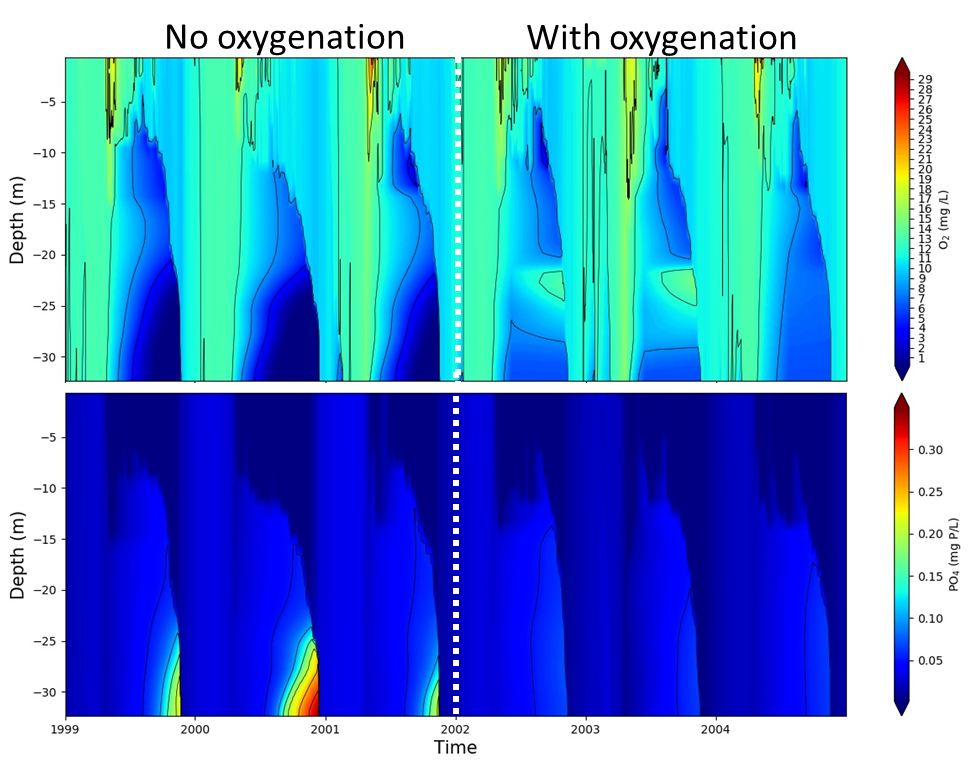
A recent example include the testing of a new manipulation routine of GOTM-WET, which enable simulation of, for example, biomanipulation by removal of zooplanktivorous fish, or oxygenation of bottom waters (example below) to reduce internal nutrient loading. The full model test case, including all input and configuration files for calibration (and example of manipulation), is available here. To turn OFF manipulation, users must simply rename (or remove) the "manipulations.nml" file from the working directory.

Figure: Lake Ravn model simulations based on GOTM-WET. The potential effects of oxygenation is simulated using the manipulation option of GOTM-WET (with oxygenation of bottom waters starting in 2002), which has an effect on the bottom sediment release of phosphate.
