Implementation of measures in SWAT+
SWAT+ is the latest version of the Soil and Water Assessment Tool (SWAT), an ecohydrological model designed to predict the effects of land management practices on water, sediment, agricultural yields, and pesticides, operating on a daily or sub-daily time step. A detailed documentation of the model an be found here: https://swatplus.gitbook.io/io-docs/
Buffer Strips
Buffer Strips are designated area of vegetation -such as grass, trees, or shrubs- planted between agricultural fields and bodies of water (e.g., streams, rivers, lakes, or wetlands). They potentially prevent soil erosion by stabilizing the soil with plant roots, filter runoff by trapping sediments, nutrients (like nitrogen and phosphorus), and pesticides before they reach water bodies, enhance biodiversity by providing habitat for wildlife and pollinators and mitigate flooding by slowing down surface water flow.
In NORDBALT-ECOSAFE, the following input files were edited to implement buffer strips in SWAT+:
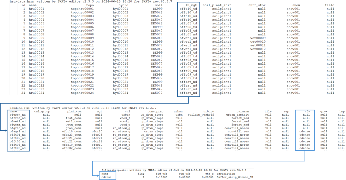
- landuse.lum: This file defines the main characteristics of the different land uses in a SWAT+ setup. To add a buffer strip to a land use, the name of the buffer strip was entered in the column vfs in landuse.lum. This column references the column name in filterstrip.str.
- filterstrip.str: This file contains an activation flag for buffer strips and parameter describing their properties, which should be set to values that are appropriate for the study area:
- flag: Buffer strip activation: 1 = active, 0 = not active.
- fld_vfs: field-to-buffer strip area ratio (recommended range: 40–60).
- con_vfs: fraction of total field runoff entering the most concentrated 10% of the buffer strip (range: 0.25–0.75).
- cha_q: fraction of concentrated flow fully channelized through the buffer strip (recommended: 0, unless the strip has failed).
- hru-data.hru (optional): The name column in this file contains primary keys that are referenced by the column lu_mgt in hru-data.hru. By default, all HRUs with the same land use will reference the same line in landuse.lum. However, to implement buffer strips in selected HRUs of a certain land use type only, a new entry needs to be created in landuse.lum, and the lu_mgt column in hru-data.hru needs to be modified, so the targeted HRUs reference the new entry whereas the remaining HRUs keep referencing the default entry.
Tip: Instead of making changes in the original landuse.lum and hru-data.hru files, create a copy of both, make the desired changes, and save them under different names. Then, change the names of the files in file.cio. Keeping both the original and modified management files allows you to easily switch between baseline and scenario runs without losing the original setup.
Fertilizer reduction
Fertilizer reduction refers to strategies and practices aimed at decreasing the amount of synthetic or organic fertilizers applied to agricultural land, without compromising crop yield or soil health. This is often done to improve environmental sustainability, reduce nutrient runoff, and lower production costs.
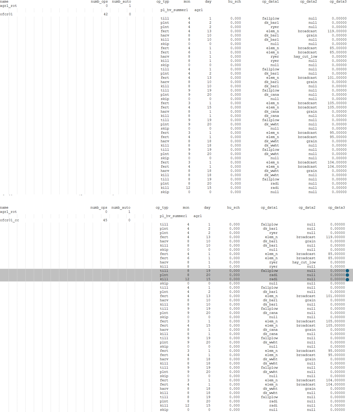
SWAT+ allows scheduling of agricultural operations (e.g., planting, fertilization, harvesting) using either management schedules or Decision Tables. In NORDBALT-ECOSAFE, we used management schedules and thus implemented the fertilizer reduction in management.sch. The amount of fertilizer applied in each fertilizer application was adjusted (column op_data3). Note: The column op_data1 specifies which kind of fertilizer is applied, so it can be used to target specific fertilizers.
When using Decision Tables, the fertilizer reduction needs to be implemented in lum.dtl: The amount of fertilizer applied in each fertilizer application is specified in the column const. The column act_type indicates which operations are fertilizer applications (fertilize) and the column option specifies which kind of fertilizer is applied. The names of all DTs that are to be used for a land use need to be listed in management.sch instead of the scheduled operations. The lum.dtl file can contain as many DTs as needed for a SWAT+ model. The individual DTs in lum.dtl are separated by a blank line. Each DT should have a unique name.
Tip: Instead of making changes in the original management.sch file, create a copy, make the desired changes, and save it under a different name. Then, change the name of the file in file.cio. Keeping both the original and modified management files allows you to easily switch between baseline and scenario runs without losing the original setup. When using Decision Tables, it is recommended to create a copy of the DT of interest in lum.dtl and change the name in a copy of management.sch accordingly. Remember to update the total number of DTs in the second line of lum.dtl when adding new DTs.
Catch Crops
Catch Crops are used to reduce nitrate leaching from soils that would otherwise be bare during the autumn and winter. They are sown in late summer and take up inorganic nitrogen from the soil during their growth period in early autumn. Catch crops also reduce soil erosion and support soil health. They can either be harvested in late autumn and the biomass used for fodder or bioenergy or they can be incorporated into the soil in late autumn to early spring to improve soil health and recycle part of the nitrogen.
SWAT+ allows scheduling of agricultural operations (e.g., planting, fertilization, harvesting) using either management schedules or Decision Tables. In NORDBALT-ECOSAFE, we used management schedules and thus implemented the catch crops in management.sch. We analyzed the crop rotations to identify years where the main crop is harvested on or before August 18 and the next main crop is not planted until the following spring. In all rotations implemented in the model, a catch crop was added in each year that met these criteria by adding three lines to the schedule: one for a tillage operation, one for planting, and one for killing the catch crop. The operations were added to the schedules in chronological order. Subsequently, the total number of scheduled operations in the column numb_ops was adjusted.
When using Decision Tables, catch crops need to be planted and harvested in a DT in lum.dtl. This can be done by expanding an existing DT or creating a new one for the catch crop. The names of all DTs that are to be used for a land use need to be listed in management.sch instead of the scheduled operations. The lum.dtl file can contain as many DTs as needed for a SWAT+ model. The individual DTs in lum.dtl are separated by a blank line. Each DT should have a unique name.
Tip: Instead of making changes in the original management.sch file, create a copy, make the desired changes, and save it under a different name. Then, change the name of the file in file.cio. Keeping both the original and modified management files allows you to easily switch between baseline and scenario runs without losing the original setup. When using Decision Tables, it is recommended to create a copy of the DT of interest in lum.dtl and change the name in a copy of management.sch accordingly. Remember to update the total number of DTs in the second line of lum.dtl when adding new DTs.
Wetland Restoration
Wetland restoration is the process of returning degraded or destroyed wetlands to a more natural, functional state. Wetlands -such as marshes, swamps, and bogs- are vital ecosystems that provide numerous environmental benefits, including water quality improvement by filtering pollutants and sediments, biodiversity enhancement by creating habitats for birds, amphibians, fish, and plants, reduction of flooding by absorbing excess rainwater and slowing runoff, carbon storage and climate change mitigation, and increasing groundwater recharge.
In NORDBALT-ECOSAFE, wetland restoration was only applied to floodplain landscape units. The following input files were edited:
- landuse.lum: A new land use was added for restored wetlands. If there are wetlands in the SWAT+ setup already, the existing wetland land use can be used for the restored wetlands.
- plant.ini: A new plant community was created for the restored wetlands.
- hru-data.hru: For the HRUs that were selected for wetland restoration, the land use was changed in the column lu_mgt to refence the new land use in landuse.lum, and a name was added for each of them in the column surf_stor, which references the column name in wetland.wet.
- wetland.wet: For each restored wetland, one line was added to this file. In line with the wetlands already included in the default setup, each restored wetland references the same line in the wetland initialization (initial.res), release (res_rel.dtl), sediment (sediment.res), and nutrient (nutrients.res) files, but a unique line in the wetland hydrology (hydrology.wet) file.
- hydrology.wet: For each restored wetland, one line was added to this file. The parameter values were kept the same for all existing and restored wetlands.
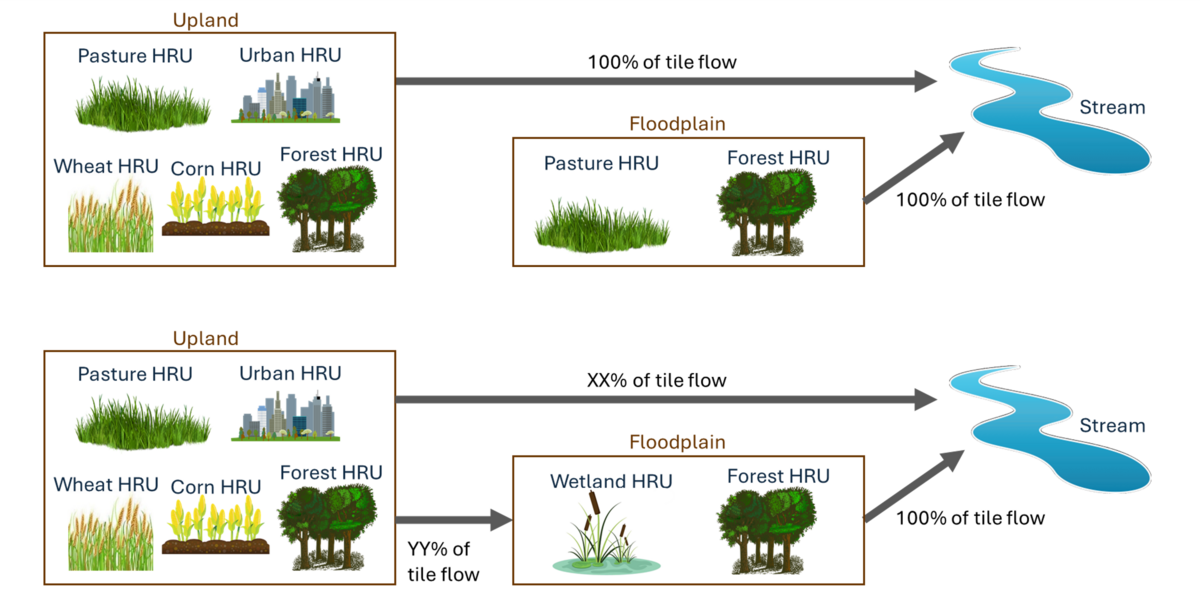
- rout_unit.con: The connectivity of tile flow from the upland was changed based on the assumption that tiles running under restored wetlands will be disconnected, so the water is flowing into the wetlands instead of the stream. To achieve this in the model, part of the tile flow generated in upland landscape units was sent to the corresponding floodplain landscape unit instead of directly to the channel. The fraction of tile flow going to the floodplain was varied across the catchment depending on the extent of total wetland area in the floodplain.


