This report summarizes the excavation campaign which was undertaken in Jerash between 20 July and 29 August 2015 by the team from Aarhus University, Denmark, and Ruhr-Universität Bochum, Germany, under the joint direction of Prof. Dr. Rubina Raja and Prof. Dr. Achim Lichtenberger.
Following our survey campaign in 2011 and the excavation campaign in 2012-2014, the subject of this year’s campaign was to further investigate particular archaeological remains in the northwest area of the city beginning west of the sanctuary of Artemis and stretching to the city wall.
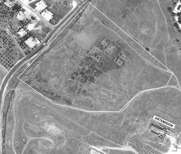
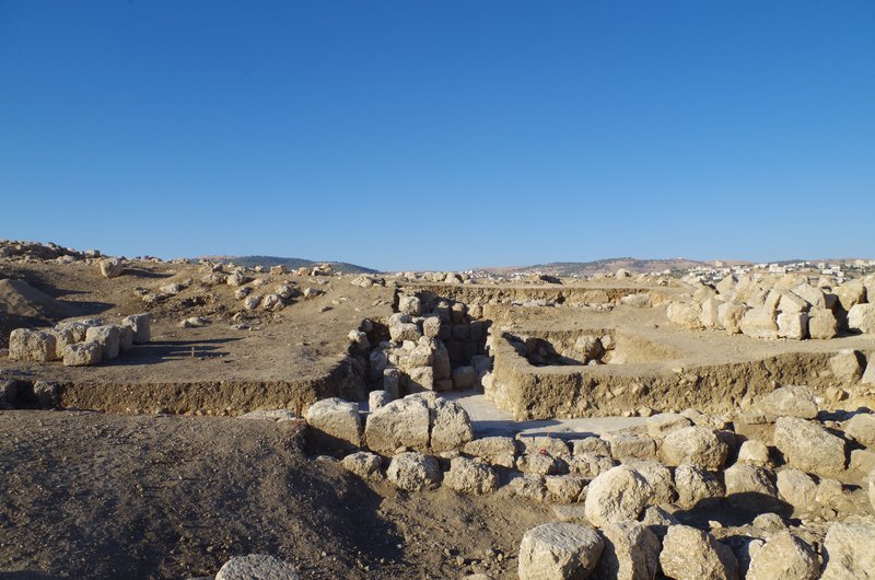
The area is the highest within the ancient city of Jerash, and it forms a natural hill which slopes to all four sides (fig. 1). The north side is a steep rock, to the east the hill descends considerably towards the Artemision, and to the south several terraces form the sloping hill creating the impression of a smoother descending hill.
In the survey of 2011 our results pointed to mainly late Roman/Byzantine and early Islamic remains in the Northwest Quarter, which the excavation campaigns in 2012 confirmed. In 2013 the results also indicated a considerable Mamluk settlement covering parts of the top of the Northwest Quarter. In 2014 the excavations gave new information about earthquake destruction in 749 CE when we were able to excavate an Umayyad house with many well-preserved finds (2014: trench K). Another important result was the excavation of a cave complex in trench J which could not be finished and with the help of the DoA was covered to be continued in 2015. Unfortunately, when we arrived in 2015, heavy illicit excavation had taken place and most of the inventory has been destroyed.
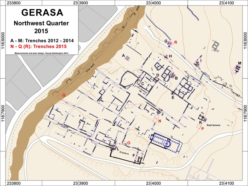
Through the excavation campaign 2015, we wanted to gain a more detailed insight into the settlement history of the area and especially its possible earlier phases. On the basis of our survey results of 2011 and the results of the 2012-2014 excavation campaigns, we chose five excavation areas and continued work in one trench from last year (trench J) which had not been finished then (fig. 2):
In all trenches, no built structures dating to before the Roman were found. Significant remains of the Roman period stem from trenches N, P and Q. There is extensive evidence for Byzantine and early Islamic settlement on the eastern terrace of the hill, as well as on the south slope of the hill. In trench N, a large probably ecclesiastical complex was found. It is the intention to explore all these areas further in the coming years in order to understand the continuity and change in settlement patterns in the Northwest Quarter of Jerash.
The project team consisted of the two directors in charge of the project, Prof. Dr. Achim Lichtenberger and Prof. Dr. Rubina Raja, assisted by Dr. Georg Kalaitzoglou (head of the field), Dr. Annette H. Sørensen and Heike Möller (head of the registration).
The field excavation team consisted of five trench masters and one trench master assistant. The field excavation team was assisted by between 12-26 workers for the duration of the excavation campaign. The documentation in the field was done by drawing profiles and plans/sketches with the help of a pantograph and photogrammetic documentation as well (3D-drawing). Photographic documentation with standard photography but also with a drone as well as geodetic documentation with a total station was also undertaken. Some special evidences in trench Q were also 3D-scanned. All measurements were entered into the CAD during the campaign. Photogrammetric documentation was also undertaken by Hans-Peter Klossek and the head of the field. Furthermore, special finds were recorded, and all pottery was registered.
All finds were processed by the registration team, which was headed by Dr. Annette H. Sørensen and Heike Möller. The registration processed all finds from the 2015 campaign, so that all excavated objects are documented. The registration team consisted of, apart from the heads, four for sorting and counting pottery, seven for drawing it and two in charge of photography. In the registration ceramic sherds were washed, sorted, counted, and diagnostic sherds were registered, described, drawn and photographed. Metal, stone, bone and glass finds were similarly registered, some of them 3D-scanned (fig. 14). Some finds required special treatment which was undertaken by the conservator, Margit Petersen. Architectural elements were drawn and documented by the architect, Nicole Pieper. Find coins from the 2012-2015 were all registered by two numismatists, Ingrid and Dr. Wolfgang Schulze. Glass from 2013 and 2014 was documented by Dr. Holger Schwarzer and a bone specialist, Dr. Pernille Bangsgaard, studied the bones from the present and earlier campaigns.
Furthermore, Peter H. Mikkelsen, Moesgaard Museum, Denmark (Director, Natural Science and Conservation Department, Moesgaard Museum, Denmark) and Peter M. Jensen, Moesgaard Museum, Denmark (PhD student, Natural Science and Conservation Department, Moesgaard Museum, Denmark) worked on the archaeobotany of the site and Prof. Dr. Ian Simpson, Stirling University, UK (Geochemistry) together with Dr. Søren M. Kristiansen, Aarhus University, Denmark (Geochemistry) worked on erosion processes and soil formation and took several samples for further analysis.
The main objective of work in trench J was to continue excavation of the cave complex which we found last year and to continue in a northern sector, north of a Mamluk wall the investigation of a possible street level of the so-called middle street.
Unfortunately the protection roof which was built by the DoA in 2014 could not prevent extensive illicit excavation in this trench. Several people must have excavated here during spring for approx. 2 weeks. They completely destroyed the inventory of the cave room and also destroyed the south wall of the cave. They continued excavation into the soil and found another cave room which they also robbed. This heavy damage to the trench did not allow us to continue further in the cave, but it is increasingly clear that the cave had been used as an oil press before it was closed.
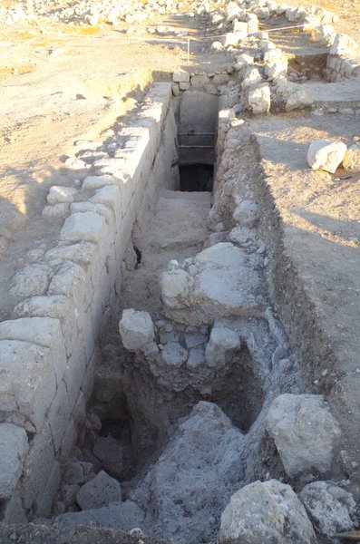
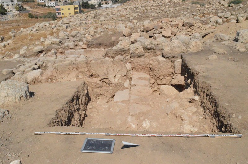
We excavated the staircase further to the east and reached its end. From the end of the staircase an opening to the north must have given access (fig. 3). In the northern sectors of the trench, it became clear that indeed a street was running west-east, and that this street was built of compact mortar floor (fig. 4).
The trench was excavated and documented by trenchmaster Ulrike Rübesam between July 22nd and August 28th 2015.
See also report on 2014 campaign.
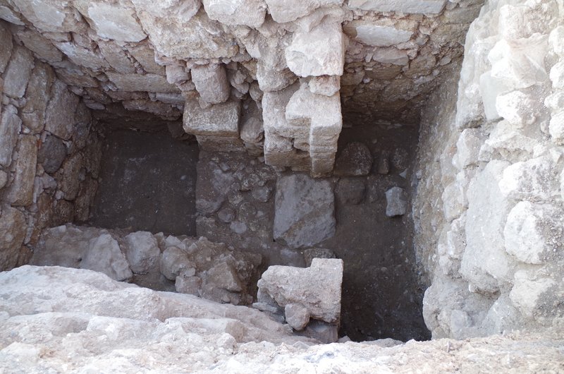
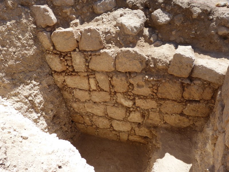
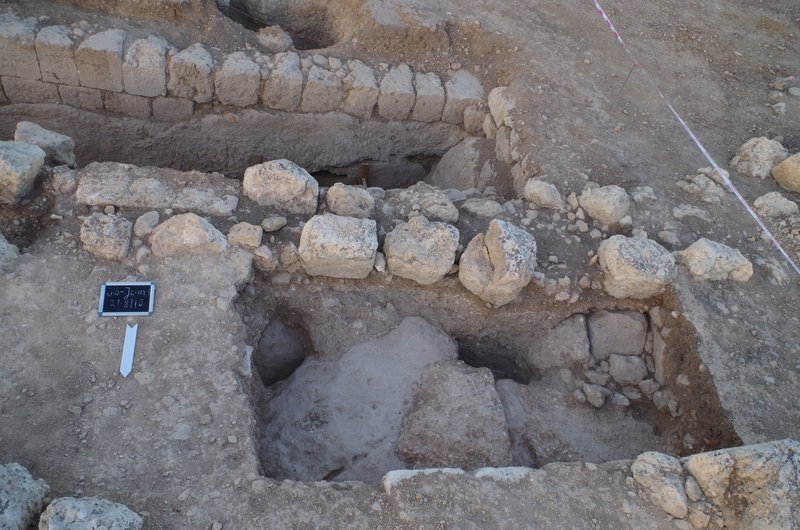
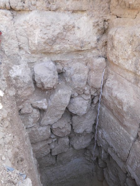
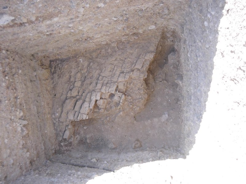
Trench N (fig. 5) was a continuation of the work started in trench J (2014), and the purpose was to investigate the southern side and the entrance to the cave complex. The trench was laid out over the presumed rock edge and entrance, and the rock cut entrance was found (fig. 6). The cave was accessible through a door from the west to enter a small anteroom from which the cave opened to the North. The anteroom was enclosed by two massive walls on the Eastern and on the Southern side. The cave was smaller than the cave found in 2014, but it was connected to it, and it is probable that the cave was also part of the same olive oil press installation.
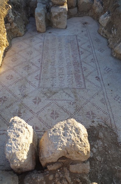
South of the massive east-west running wall, to our surprise, a large room with mosaic floor was found (fig. 7). The floor was decorated in fields and had geometric patterns, as well as two Christian inscriptions: One in a tabula ansata, the other in a medallion. Both are well dated into the later 6th century CE. The room with the mosaic had an extension of at least 9 x 15 m, but since the eastern border was not reached, and the room was only partly excavated, it could have been considerably longer. It could be established that the room had an inner wall at the center which allowed roofing of the complex. This ensemble, which could be only partially excavated during this campaign, probably belonged to the church further to the south.
Sometime before the earthquake of 749 CE, the large room with the mosaic was transformed into several smaller rooms by the implementation of several division walls, which all respected the mosaic floor. Pottery found on the floor dates to the early Islamic period. The whole evidence is of special significance, since it attests to the transformation of ecclesiastical spaces after the Islamic conquest.
The trench was excavated and documented by trenchmaster Ulrike Rübesam between July 22nd and August 28th 2015. Since only part of the complex was excavated, and its architectural layout is not yet fully understood, it is crucial to continue excavation in this area in 2016.

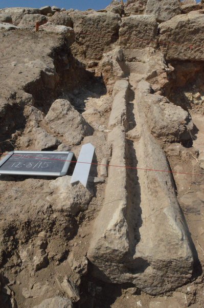
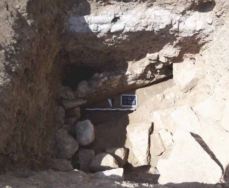
The trench was laid out at the northwest corner of the large cistern on the south slope of the Northwest Quarter. This large cistern had been partly subject to excavation in 2013 and 2014 (trenches F and L). The aim of the new trench was to investigate the possible water inlet and a possible sediment basin of the large cistern. This aim was not satisfyingly achieved. What was found in the trench was an Early Islamic alley(?) from south to north with one house to the West and a water channel running along this alley(?) on walking level (fig. 8). The southern continuation of this channel had been found in trench L last year (2014). East of this was a densely packed podium into which we made a deep sondage and found some Roman material and possible water installations. Among the Roman material was a bowl with bronze pigments for coloring (fig. 9). These might have been related to an adjoining room to the East, in which a very strong mortar floor had been found which could have been related to a water basin, but this needs further investigation. Later, in the early Islamic period, this area was used as a house.
Due to later buildings which we did not remove, it was impossible to clarify the exact relationship between the strong mortar floor and the Roman/Late Roman phases of the large cistern, but we hope that geochemical analysis of the mortar will help to understand it better. The most important result of this trench is the reconstruction of extensive Byzantine and early Islamic building activity post-dating the large cistern (fig. 10). All evidence retrieved could be related to trenches F (2013) and L (2014) and support our previous assumptions. To better understand the functioning of the cistern, it is important to continue excavation in this area in 2016. The trench was excavated and documented by trenchmaster Malene Byø between July 22nd and August 28th 2015.
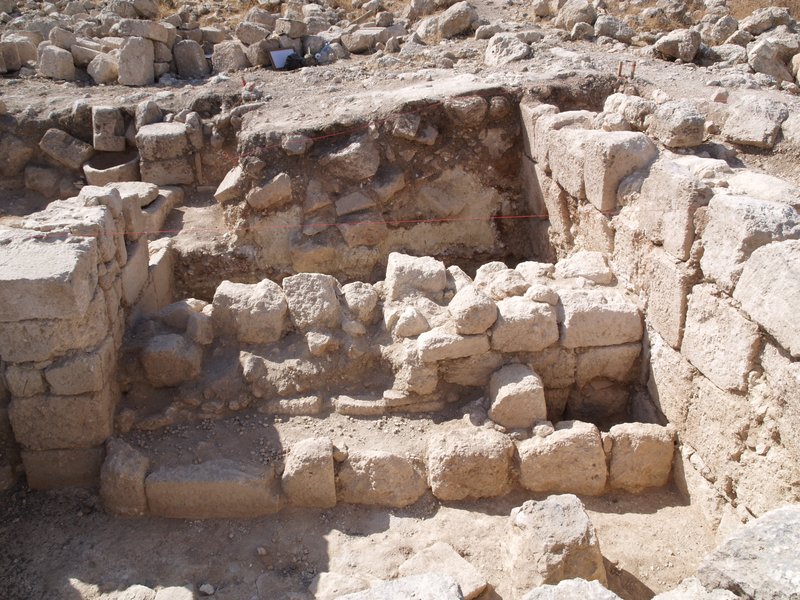
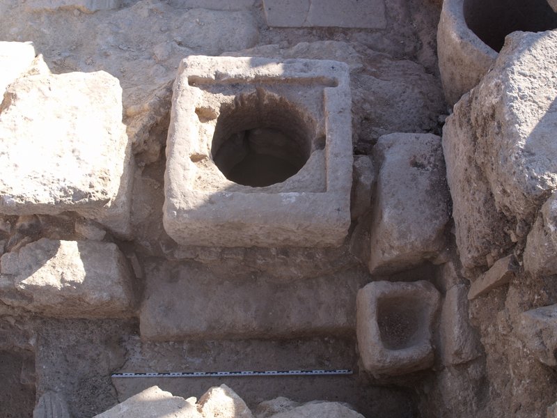
After we had found in the 2014 campaign a well-preserved Umayyad house with rich domestic inventory (trench K), it was decided to continue investigation of this area (eastern terrace) in this campaign. The trench was laid out further south of the 2014 trench in a flat area where little structures were visible on surface. Excavation revealed parts of a larger Umayyad complex that probably has been destroyed in the 749 CE earthquake (fig. 11). We excavated a well-built staircase that from the southwest led into an open(?) area with a cistern. The cistern had a nicely cut well-head (two phases) (fig. 12) and the cistern itself was pear-shaped, ca. 3.50 m deep, and apart from some collapse empty. The cistern was fed by a channel that led water, collected on the roof, into it. Close to the cistern, several basins were also found.
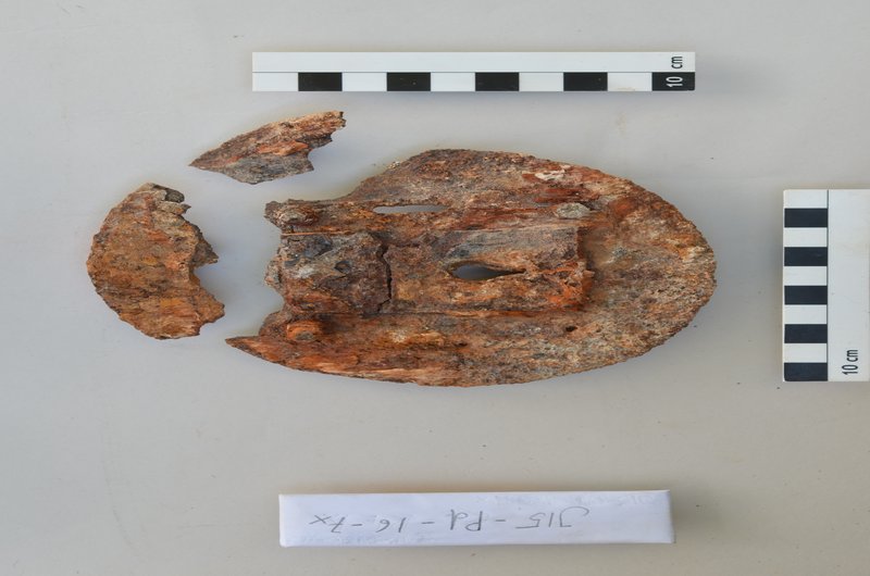
From the open cistern court, a door to another room to the east opened. Also to the North, there was an opening to a room. This opening was given by an arch, and a second arch runs in a line further to the east. Both opened to a room which at one point was divided by an intermediate wall running north-south (fig. 11). Attached to the eastern side of this later wall, a stone built trough was constructed that ran along the wall and that was completely filled with white unused tesserae. This evidence probably has to be interpreted as a preparation of laying new mosaic in one room of the house. Apart from many iron items probably belonging to a wooden door (fig. 13), little finds were made in this part of the room, and it seems that part of the house underwent renovation when it was destroyed in the earthquake. This is also supported by the find of a small basin with lumps of mortar in it which was used for some preparation of mortar (fig. 14) and also by several fragments of wall plater with intentional cut marks on the surface for preparing for a new layer of wall plaster.
In the collapse of the room many fragments of mosaic stones, partly still in larger formations with bedding, were found. Since they were found quite high within the room and since no mosaic floor could be observed on the ground floor, we have to assume that the first floor of the building had a mosaic floor.
The trench was excavated and documented by trenchmaster Line E. Nielsen between July 22nd and August 28th 2015.
This trench as last year's trench K gives important insight into the latest Umayyad phase of Jerash, and it provides us with undisturbed and well-preserved layers. Therefore, it is planned to continue excavation on the east terrace in 2016, and a new trench should be laid out further south.
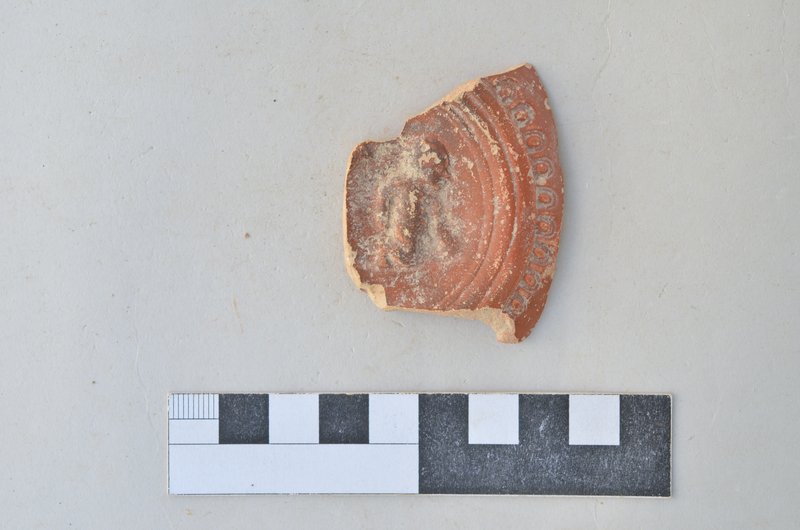
This trench, which was laid out at the city walls of Jerash with a stretch of a tower. Since the dating of the city walls of Jerash is contested, it was the aim of this trench to investigate the date of construction of the city walls and its relationship to intramural buildings. Excavation took place from both sides of the city wall, inside and outside. From both sides, the fundaments of the city walls were reached (fig. 15). The fundaments especially from the inside but also partly from the outside were filled with much pottery and other finds of a Roman date (fig. 16). They need to be further investigated, but this evidence supports a Roman date of construction of the walls.
Approx. 2 m east of the city walls, another later wall was constructed which in the excavated stretch ran parallel to the city walls (fig. 17). Further to the south, an older well-built terrace wall running east-west was found. Unfortunately, its relationship to the city walls could not be determined, since their projected meeting point could not be covered by the trench.
In the eastern part of the trench, a pressure pipe (higher level) and a water canal (lower level, on bed rock) were found. They are running east-west in a slightly oblique angle towards the south. It could not be established whether the canal was a sewer or a freshwater canal, but geochemical analysis will help to determine. We tried to trace the course of these two water lines outside the city walls, but we did not find them. Therefore, the lower water canal either was cut by the construction of the city walls, or it ran along the inside of the city walls and was only crossing them in the area of a gate. The analysis of the mortar of the channel will probably give an answer to this important question for the date of construction and the planning of the city walls.
The trench was excavated and documented by trenchmaster Alessandra Esposito assisted by Sören Pfeiffer between July 22nd and August 28th 2015.
This small trench was laid out on the northern slope of the Northwest Quarter. Its main aim was to analyze the different layers of erosion and human activity in this area. From our earlier excavations (2013 and 2014) in this area, we already knew that we would probably not encounter built structures, and this was the case. As we had known before, this area was mainly used for gardening, and therefore, we took many archaeobotanical and soil chemistry samples in the sequence of layers dating from the Roman period to modern times (fig. 18). This will help to better understand erosion processes, human activity and farming in this part of the Northwest Quarter. The samples will now be analyzed in the UK and Denmark.
The trench was excavated and documented by trenchmaster Sören Pfeiffer between July 22nd and August 23th 2015.
All trenches were backfilled after excavation. After consultation with specialists in mosaic conservation, we decided to cover the well-preserved mosaic floors in trench N with the natural soil, which we had excavated. We decided not to use geotextiles since that involves more potential problems than using the soil. After covering the mosaics with soil, we also put large stones on top of it to prevent vegetation and keep illicit activity away.
The conservation campaign ran from 6th August to 28th August 2015 staffed by M.Sc. in conservation Margit Petersen from Viborg Museum, Denmark. The conservation lab was set up in the kitchen of courtyard C in the Archaeologists’ Camp. Easy access to running water, natural daylight and outdoor facilities were essential for several of the work procedures. The equipment consisted of a stereo microscope with photo attachment, a vacuum chamber run by a hand driven vacuum pump, rotating tools, an ultrasonic scaler, assorted hand tools and conservation chemicals. Conservation records were added by hand to the printed basic registration sheets generated by the project.
The results of the 2012-2014 campaigns showing an intensive Byzantine and Islamic settlement in the Northwest quarter of Jerash were substantiated by the research undertaken in the 2015 campaign. In all trenches, we found extensive Byzantine and Early Islamic occupation. But this year, also more Roman material was detected than in previous years. This relates to the construction of the city walls (trench Q) but also to the first phase of use of the cave complex as an oil press (trenches J and N) and to some, until now, not yet clearly specified activity in the area around the large cistern (trench O).
Some important further results need to be summarized: (1) We gained new data for the date of the construction of the city walls, which at least in the excavated area clearly dates to the Roman period. Further analysis of the finds will refine this date. (2) Again, we found impressive remains of late Umayyad buildings on the eastern terrace and (3) We found parts of a larger ecclesiastical complex which was related to the church south of it. It has mosaic inscriptions and nice geometrically decorated mosaic floors. This complex is of special importance because it is obviously one of the largest public buildings in the Northwest Quarter, and furthermore, it presents important data for transformation processes in the aftermath of the Islamic conquest.
On the basis of these results, we want to lay out six carefully selected trenches in the 2016 campaign. Four of them are directly related and follow-up of this year’s trenches. Two trenches need to be laid out east and west of the ecclesiastical complex to further investigate its architecture and its inventory. Another trench needs to be excavated east of trench O to continue excavation in the area of the large cistern and to finally clarify the water inlet of this cistern. Furthermore, one trench should be laid out in the middle of the southern slope of the Northwest Quarter because the whole area and its buildings have not yet been investigated. And finally, we intend to go back to trench A from the 2012 campaign and excavate an adjacent area in which we now, after intensive study of the excavated material, assume a larger Roman construction.
The directors and the team were supported by members of the DoA throughout the campaign. We thank the general director, Dr. Munther D. Jamhawi, for facilitating our preparations for the campaign. At the Department of Antiquities in Jerash, especially Ahmad Shami supported us scientifically and with the practical organization and infrastructure. Our DoA representatives, engineer Ali Oweisi and Akram Atoum, were also very supportive throughout our campaign. We were able to reach them anytime, and they accompanied our work. Also the stay in the Archaeologists’ Camp contributed to efficient workflows, and we thank Mohammed Ghazi for his competent and efficient help in all matters concerning these issues. We would also like to thank Aktham Oweidi for professional and friendly advice and guidance, as well as Ahmed Lash. We would like to thank the DoA for its good cooperation, which we hope to continue in the future. We would also like to mention that the German Protestant Institute of Archaeology in Amman has supported us with considerable help.
Akram Atoum (21st July until 9th August 2015)
Engineer Ali Oweisi (10th August until 29th August 2015)
The team consisted of the two directors Achim Lichtenberger and Rubina Raja, head of the field team Georg Kalaitzoglou, head of the registration team Annette H. Sørensen and Heike Möller, archaeobotanists and archaeologists Peter H. Mikkelsen and Peter M. Jensen, architect Nicole Pieper, bone specialist Pernille Bangsgaar, coin specialists Wolfgang und Ingrid Schulze, conservator Margit Petersen, geochemists Ian Simpson and Søren M. Kristiansen, glas specialist Holger Schwarzer and the field and registration team: Malene Byø, Philip Ebeling, Julian Einschenk, Alessandra Esposito, Luisa Goldammer-Brill, Niels B. Hansen, Charlotte B. Hove, Nicole Jezewicz, Hans-Peter Klossek, Kevin Kremser, Mie E. Lind, Kevin Luijer, Line E. Nielsen, Mette N. Pedersen, Alex H. Peterson, Sören Pfeiffer, Sara Ringsborg, Ulrike Rübesam, Karen E. Spencer, Janek Sundahl and Nicolai B. Thorning.
