This report summarizes the excavation campaign which was undertaken in Jerash between 21st July and 31st August 2014 by the team from Aarhus University, Denmark and Ruhr-Universität Bochum, Germany under the joint direction of Prof. Dr. Rubina Raja and Prof. Dr. Achim Lichtenberger.
Following our survey campaign in 2011 and the excavation campaign in 2012 (see our 2011, 2012 and 2013 reports in Munjazaat) the subject of this year’s campaign was to further investigate particular archaeological remains in the northwest area of the city beginning west of the sanctuary of Artemis and stretching to the city wall.
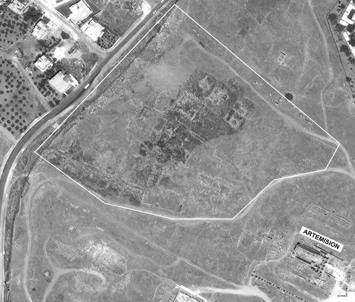
The area is the highest within the ancient city of Jerash and it forms a natural hill which slopes to all four sides (fig. 1). The north side is a steep rock, to the east the hill descends considerably towards the Artemision, and to the south several terraces form the sloping hill creating the impression of a smoother descending hill.
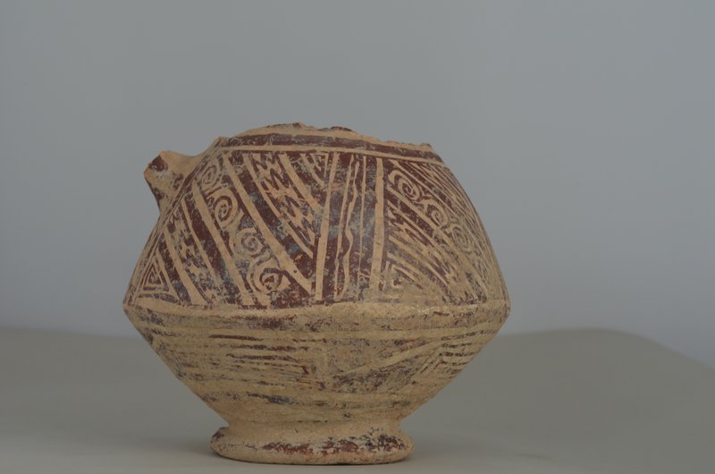
In the survey of 2011 our results pointed to mainly late Roman/Byzantine and early Islamic remains in the Northwest Quarter, which the excavation campaigns in 2012 and 2013 confirmed (fig. 2). Through the excavation campaign 2014 we wanted to gain a more detailed insight into the settlement history of the area and especially its possible earlier phases.
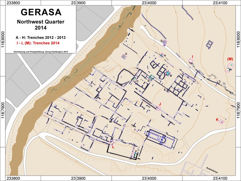
On the basis of our survey results of 2011 and the results of the 2012 and 2013 excavation campaigns we chose five excavation areas.
In all trenches no built structures dating to before the Late Roman/Byzantine periods were found, dense occupation can be traced in the Byzantine/Early Islamic period. However, scattered remains from earlier periods indicate limited occupation. Important results for the overall settlement history concern the course of the North Decumanus, water supply and the general development of the Northwest Quarter.
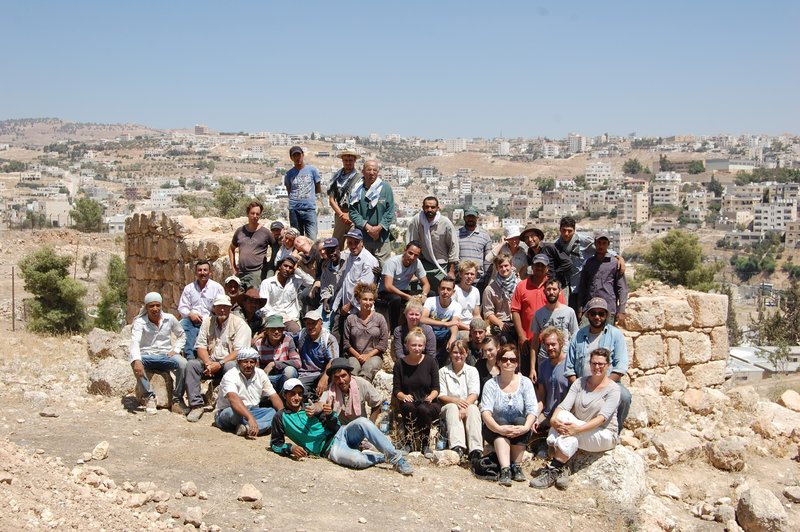
The team consisted of the two directors in charge of the project, Prof. Dr. Achim Lichtenberger and Prof. Dr. Rubina Raja assisted by Dr. Georg Kalaitzoglou (head of the field) and Dr. Annette H. Sørensen (head of the registration).
The field excavation team consisted of four trench masters. The field excavation team was assisted by between 12-26 workers for the duration of the excavation campaign. The documentation in the field was done by drawing profiles and plans/sketches with the help of a pantograph. Photographic documentation as well as geodetic documentation with a total station was also undertaken. All measurements were entered into the CAD during the campaign. Photogrammetric documentation was also undertaken by the head of the field and a surveyor student. Furthermore special finds were recorded and all ceramic was registered. The latter was processed by the registration team, which was headed by Dr. Annette H. Sørensen. The registration team consisted of, apart from the head, two for sorting and counting pottery, five for drawing it and one in charge of photography. Furthermore, an assistant typed in all finds from former campaigns into an excel sheet for registration in a currently developed database.
In the registration ceramic sherds were washed, sorted, counted and diagnostic sherds were registered, described, drawn and photographed. Metal, stone, bone and glass finds were similarly registered. Some finds required special treatment which was undertaken by the conservator, Margit Pedersen. Architectural elements were drawn and documented by the architect, Jens C. Pinborg, using an SMF based computer programme and inked paper drawings. Furthermore a geologist, Peter F. Jensen, used an XRF scanner on selected finds, such as sculpture, glass, metal and painted finds. A geologist, Dr. Alf Lindroos (Åbo University, Finland) took mortar samples for further dating analysis with the refined AMS-method. In addition to the mortar samples several charcoal samples were taken and they will be 14C dated after the campaign in order to refine the chronology. A bone specialist, Dr. Pernille Bangsgaard, examined bones from the campaigns 2012-2014.
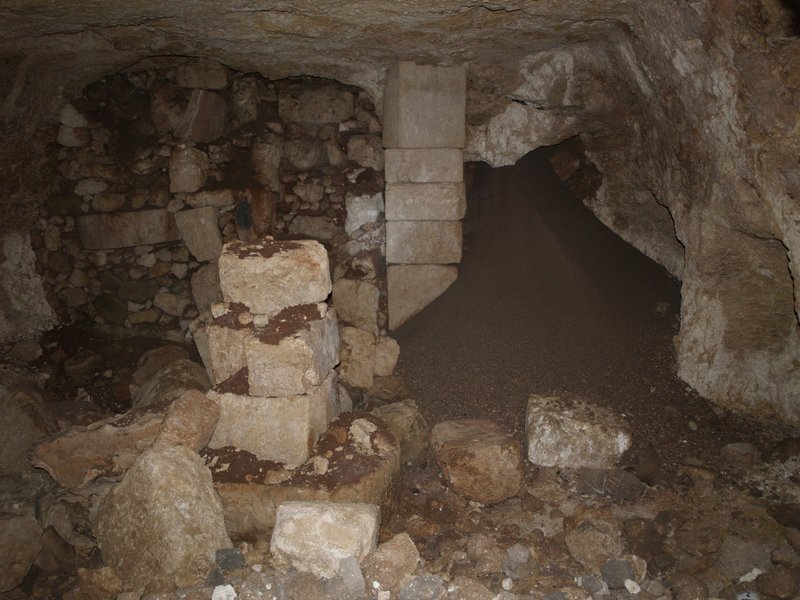
The main objective for laying out trench I was to investigate the possible continuation of the North Decumanus running east-west from the Tetrapylon to the area of the North Theatre. Furthermore the trench also allowed examination of an area with a cave that was partly visible and the nature of which needed to be clarified. One of the aims was to check the hypothesis put forward by some scholars that the caves in this area might have been used as tombs. The trench was located on the slope of the north side of the hill app. 20 metres from trench G excavated in 2013 and 40 metres from trench M, an area already excavated by an American-British team in 1982. The location of the trench was chosen because trench G had not yielded any results pointing to a continuation of the North Decumanus and it therefore was necessary to check whether a possible North Decumanus would have run until the projected turn in the bedrock towards the south. Furthermore the trench excavated in the 1980s had not yielded conclusive results regarding the possible continuation of the North Decumanus either and therefore trench I would clarify the question of the existence of a street in the Roman period in this area.
Excavation and documentation in trench I was conducted from 21st July to 30th August 2014 and was supervised by Line E. Nielsen. Trench I measured 6 meters by 5 meters and was later extended by 1.5 meters by 10 meters towards the North.
The trench was mostly excavated fully to bedrock, virgin soil or structures which should be preserved. The northern extension sectors were not excavated fully since the northernmost ones yielded bedrock and virgin soil and therefore the result that there definitely was not a street running east-west in this area.
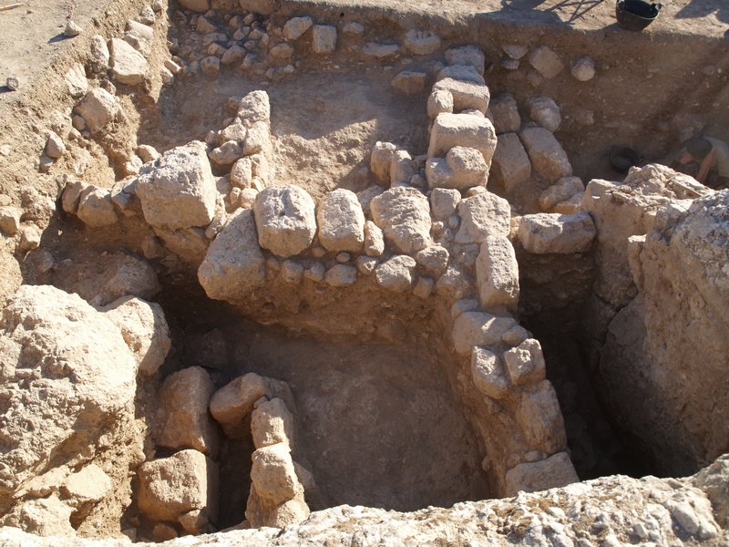
The overall results gained from the finds in trench I showed several phases of use the latest of which seem to be a Mamluk phase (fig. 4). The earliest phases of occupation, which until now cannot be securely dated, include substantial wall structures running north-south protruding from the worked bedrock and a cave. These give the clear impression of habitation structures set against and using the bedrock as a back wall and the small cave as a room. At a later point this complex fell out of use and re-occupation of the area took place on a much smaller level, but also using the cave as the back of another room.

The main objective for laying out trench M was to clarify whether the North Decumanus continued in this area. This trench, which had been partly excavated in 1982 by Clark and Bowsher needed to be reexamined as it never had been properly published and was not excavated fully to bedrock or virgin soil. The area is important for our understanding of the possible extension of the North Decumanus to the West.
Trench M was excavated and documented between 15th and 30th August 2014. The work was supervised by Line E. Nielsen. The trench was located to the north of the north slope of the hill. Two in-situ columns had already been partly visible when the trench was excavated in 1982. Behind these columns a well-constructed wall ran in several courses. This wall is set on bedrock which stretches towards the south. Further to the south a line of stones ran in east-west direction through the trench. The southern side of the trench excavated by Clark and Bowsher was not the objective of reexamination.
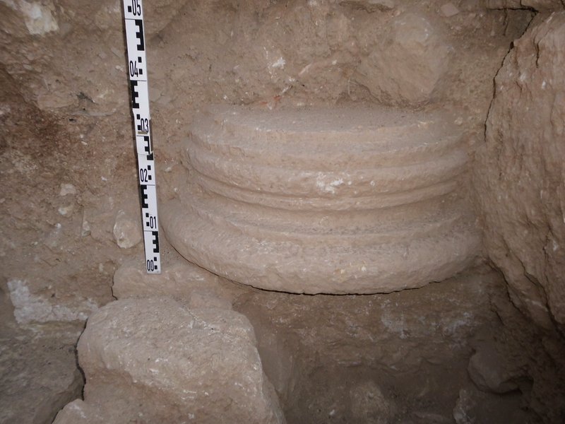
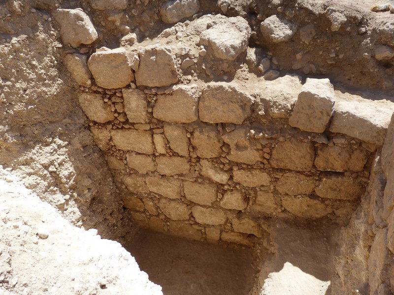
The re-excavation of trench M brought several new features to light. Firstly the line of stones running east-west through the trench turned out to be a stone constructed covered water channel which was mortared on the inside. Mortar samples were taken from this channel for AMS mortar analysis. Secondly a third column basis came to light in the easternmost part of the trench confirming that the structure continues further towards the East. All three columns were standing on punctual stylobates standing on the bedrock and in front of them a rock cut “channel” runs, which might have been a fundamentation pit (fig. 6). Thirdly there does not seem to have run a street (“North Decumanus”) to the north of the structure. The nature of this structure, which very well may have been a façade monument, remains to be further investigated.
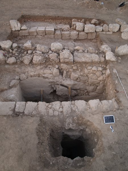
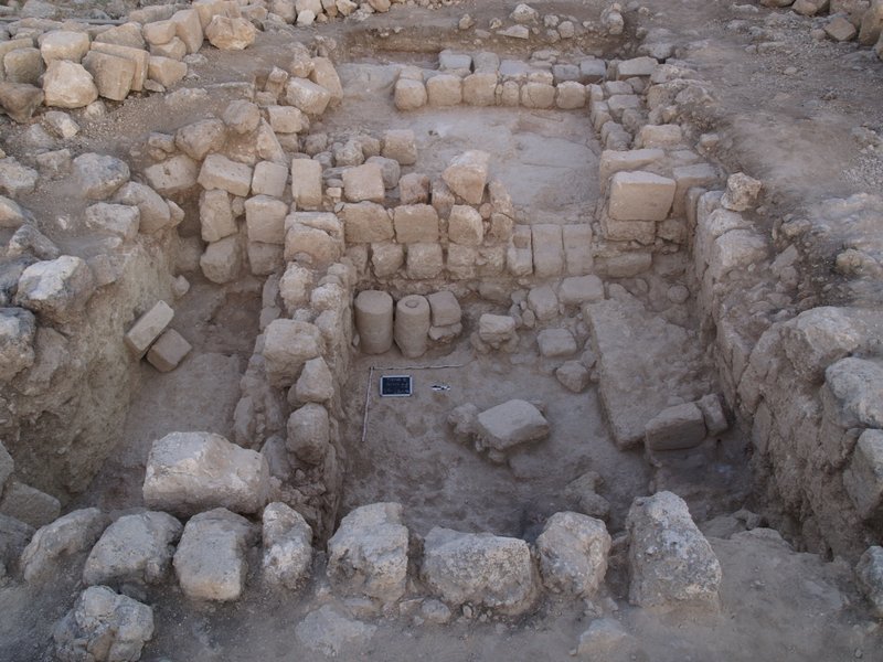
The trench was laid out on the south side of the large rectangular terrace structure stretching in east-west direction in front of the so-called “Ionic Building”, which has turned out to have early Islamic as well as Mamluk phases documented through the excavations undertaken there in the 2012 and 2013 campaigns. Trench J was excavated and documented by Ulrike Rübesam in the period between 21st July and 30th August 2014. The aim of the trench was to investigate the relationship between the terrace wall on the south side of the terrace complex and the area to the south. The geophysical investigations conducted in 2011 had shown anomalies in this area indicating a wedge-shaped string of rooms running east-west outside the terrace area.
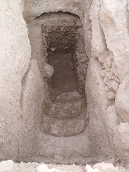
The trench was laid out as a 5 meters by 5 meters square trench catching the inside of the terrace, the terrace wall as well as the outside of the terrace to the south where another wall was running east-west (fig. 7). Between the wall located outside of the terrace and the remaining area to the south bedrock was soon reached. However, the bedrock turned out to be cut deep down to a depth of 5 meters. The fill from surface to the bottom of the cut bedrock was full of pottery dating to mainly between the 3rd and 5th centuries CE. The fill was extremely dense and there was more pottery than soil in some of the layers. At the level of app. 4 meters three cave structures were encountered, which were also completely filled up intentionally. Towards the west a staircase ascended, which was also cut into the bedrock (fig. 8). The full length to the surface of this staircase was not excavated due to the lack of time, but it is assumed that it led all the way to the surface. The cave structures to the north and the west were not very large and partly natural partly artificial. In the area in front of the three caves two fire places came to light. An entrance to a larger cave complex was encountered at the south side where a door opening was situated. This door opened a short corridor leading to a large open cave room on a lower level. In the ceiling of the corridor a shaft opened that led to the surface. The corridor had been blocked with walls and filled in from above through the shaft. This fill contained mainly material from the 6th/7th centuries CE.
Behind this fill a large cave, partly natural and partly worked came to light. It measured app. 7.5 meters by 6.5 meters (fig. 9). On the west side it had three roughly worked niches, on the east side it was vertically worked and on the south side it was blocked completely up by an artificially constructed back wall. Within the back wall a blocked door is visible that probably led to another room to the south. App. in the middle of the back wall stood a support pier which was constructed by several well-worked blocks. It had been slightly moved out of place by a collapse in the bedrock which could be detected by a large piece of bedrock which had come partly loose and was pressing against the support. Another pier was standing in the center of the cave, but it had partly collapsed. One large mill stone made up the bottom of this central support. Another one was built into one of the courses of the artificially constructed back wall. The cave was fairly void of any finds belonging to the last phase of use, a few pottery sherds were found, but these may have belonged to the fill layers. It seems as if the cave had been cleaned out before it was closed off. There were no traces of the cave having been used as either a grave or as a complex for cultic activities. Rather it seems to have been a complex for domestic or industrial usage, perhaps as a basement for a housing complex on the surface. The complex has two main phases of use.
In one main phase, the staircase was an access to the cave complex. Probably around the 5th century it was blocked and backfilled. To this also belong the tabuns in the staircase area. From then on the large cave probably only was accessible through the door in its southern wall and also the shaft probably gave access to the cave. At a later point in time, possibly in the 7th century CE also this shaft was blocked and then, also the south wall with the entrance was closed and the cave was sealed.
The trench was not backfilled at the end of the campaign. In cooperation with the DoA in Jerash it was covered by a metal construction strengthened with a stone layer and soil in order to protect it, so that work can be continued there in the coming campaign in 2015. The complex and the use of man-made underground structures of these dimensions raise several questions about the phases of settlement in the Northwest Quarter of Jerash.
The trench was laid out at the eastern terrace of the Northwest Quarter, to the west of the monumental sanctuary of Artemis and the east of the east end of the terrace in front of the so-called “Ionic Building”. The aim of the trench was to investigate activity in this area, which seems to have been heavily disturbed by destruction as seen through the many larger stone blocks which lay scattered across the complete area of the east terrace. The trench was excavated and documented by Till Flüchter in the period between 21th July and 30th August 2014.
The trench measured 5 x 5 meters and was later extended to the west with another 5 x 5 meters.
As in all of this area, the so-called eastern terrace, many collapsed stones were laying on the surface. In the trench many of the collapsed stones could be dated to the late Hellenistic and Roman periods due to the technique with which they were worked and their overall stylistic expression (dressed margins). The technique comes most closely to the technique used in the late Hellenistic phases of the Sanctuary of Zeus in the southern part of the city and of the building stones of the early 2nd century CE basilica north of the North Theatre.
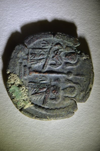
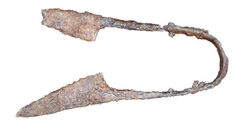
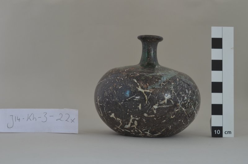
The excavated structures in trench K were comprised of two connected rooms whereof the easternmost room connected to yet another front room or courtyard in which a mortared rock-cut water channel covered by large stones running north-south through the easternmost part of the trench was discovered. To the north of the westernmost room part of another room was excavated. This room did not seem to bear any direct relation with the westernmost room of the trench. Bedrock was reached in many sectors. In the easternmost room of the trench Abbasid pottery was found, which until now has been fairly rare in Jerash. In the westernmost room a concentration of finds came to light, which included an Arab-Byzantine coin hoard of 11 coins, among these a rare specimen of a coin minted in Beisan during the early Islamic period (fig. 11). Furthermore a number of iron and bronze items which seem to have belonged to an assemblage came to light (fig. 12). The items almost all are connected with textile production and sewing. They include needles for rough materials, Byzantine weights, spindle whorls and files. In the northeastern corner of the trench several larger metal objects were found, among these a flax heckle, again indicating a connection to textile production and the working of raw materials. The concentration of Byzantine/early Islamic period finds seem to have fallen down during the collapse of a second story. Furthermore several complete glass flasks (fig. 13) were found, also belonging to the collapse of the upper story of the building. The associated pottery points to an early Islamic date.
The overall impression gained from the excavation of this trench and the belonging finds is that this complex balances on the border between the Late Byzantine period and the early Islamic period, giving insight into the continuation of the cultural traditions mixed with new impulses generated by the new rulers of the region.
Trench L was laid out on and covering the part of the area at the west end of the large rectangular cistern, the street running towards the west and the corner of the easternmost building standing on the northernmost street corner. The aim of the trench was to clarify the relationship between the cistern and the quarter on the south slope of the cistern in order to examine the chronological relationship between these features. The trench was excavated and documented by Anne D. K. Høj in the period between 21st July and 30th August 2014. The trench measured 6 x 5 meters and was later extended with 5 x 5 meters to the west as well as to the south with an extension of app. 2 x 3 meters.
The trench gave important insight into the building history of the area. Already last year’s trench F proved that probably by the end of the 6th century CE the cistern fell out of use as a water reservoir and subsequently was built with domestic/industrial structures inside.
Part of trench L was laid out in the cistern itself and in this area the western back wall of the cistern was traced. It was covered by a thick layer of mortar. In front of the mortar a dense fill layer was found which covered the cistern from the edge until app. 3 meters into the cistern, where a massive north-south running retaining wall was found. The wall was standing directly on the floor of the cistern and was preserved up to eight courses; smaller stones were set between the large courses. A structure running east-west and binding into the retaining wall was found to the south at the end of the retaining wall. This latter wall was standing on a fill foundation. In the extension towards the south the back wall of the cistern phases was also partly traced as was a massive structure, which was built into the bedrock, most likely as a post-cistern use. Later this structure had been closed off and turned into a wall. This area might have served as an entrance point to the cistern in the period in which it served as an area of housing and production. For now it is assumed that the walls formed part of a staircase construction leading down to the cistern when the cistern had fallen out of use as a water reservoir. At the same time this construction served as substructure of the street coming from the west, bending at this point to the north.
The street had several walking levels and probably belonged to the same planning phase as the houses north of it. The chronological relationship between the street, the houses north of it and the phase in which the cistern still served as a water reservoir could not yet be determined but the upcoming find analysis and 14C-dating of charcoal samples will provide us with necessary data.
All trenches were backfilled after excavation apart from Trench M, which was a re-excavation of a not back-filled trench from the 1980s and trench J which was covered with a metal construction in order to protect it and allow for continued work there during the next campaign.
The conservation campaign ran from 11th August to 30th August 2014 staffed by M.Sc. in conservation Margit Pedersen from Viborg Museum, Denmark. The equipment consisted of a stereo microscope with photo attachment, a vacuum chamber run by a hand driven vacuum pump, rotating tools, an ultrasonic scaler, assorted hand tools and conservation chemicals. Conservation records were added by hand to the printed basic registration sheets generated by the project.
The results of the 2012 and 2013 campaigns showing an intensive Late Byzantine and Islamic settlement in the Northwest quarter of Jerash was substantiated by the research undertaken in the 2014 campaign. We now have a clearer vision of the overall settlement on the hill and in 2014 we again gained much important information about the water supply of the ancient city, but also about the Late Byzantine and Islamic period housing.
Also concerning the topography of the Northwest quarter important new insights were gained: Firstly the fact that deep structures for domestic and/or production usage, cut into the bedrock in areas that seem to in their earliest phases have been used as quarries, were constructed after the quarry phases brings interesting perspectives on the development of the Northwest Quarter. Such structures have not been known until now in this part of the city. Secondly the fact that the eastern terrace seems to be covered with dense habitation from at least the Byzantine period until the Abbasid period is a new insight which will allow new perspectives on the overall urban development of Jerash in these periods. Thirdly it is now beyond doubt that the North Decumanus in the Roman period did not extend into the Northwest Quarter on the north side of the hill.
The directors and the team were supported by members of the DoA throughout the campaign. We thank the general director, Dr. Munther D. Jamhawi, for facilitating our preparations for the campaign. At the Department of Antiquities in Jerash especially Ahmad Shami supported us scientifically and with the practical organization and infrastructure.
Our DoA representatives, engineer Ali Oweisi and Akram Atoum were also supportive throughout our campaign. We were able to reach them anytime and they accompanied our work. Also the stay in the Archaeologists’ Camp contributed to efficient workflows and we thank Mohammed Ghazi for his competent and efficient help in all matters concerning these issues. We would also like to thank Hamdan Najjar for professional and friendly advice and guidance as well as Ahmad Lash. We would like to thank the DoA for its good cooperation, which we hope to continue in the future. We would also like to mention that the German Protestant Institute of Archaeology in Amman has supported us with considerable help.
DoA-representatives:
Dr. Ali Oweisi (21st July until 10th August 2014)
Akram Atoum (11th August until 31st August 2014)
The team consisted of the two directors Achim Lichtenberger and Rubina Raja, head of the field team Georg Kalaitzoglou, head of the registration team Annette H. Sørensen, architect Jens C. Pinborg, conservator Margit Petersen, geologist Alf Lindroos, XRF specialist Peter F. Jensen, bone specialist Pernille Bangsgaard and the field and registration team: Anders M. Bjerggaard, Philip Ebeling, Till Flüchter, Pawel J. Grüner, Niels B. Hansen, Ditte M. D. Hiort, Charlotte B. Hove, Anne D. K. Høj, Hans-Peter Klossek, Signe B. Kristensen, Nadia S. Larsen, Line E. Nielsen, Sara Ringsborg, Ulrike Rübesam and Janek Sundahl.