Between the 1st August and 11th September 2012 the Danish-German team from the University of Aarhus, Denmark and Ruhr-Universität Bochum, Germany conducted its second campaign in the Northwest quarter of the ancient city of Jerash. On the basis of the results of the 2011 campaign, which consisted of architectural, geodetic and geophysical surveys (see Lichtenberger – Raja 2013 and Kalaitzoglou et al. 2013 for the 2011 campaign); it was decided to lay out three trenches. These were chosen to gain further insight into the settlement history of the Northwest quarter of the city, which is the highest point within the ancient city walls and which until now has not been investigated in detail. The project, which is directed by Achim Lichtenberger and Rubina Raja, is funded by the Deutsche Forschungsgemeinschaft (DFG) and the H.P. Hjerl Hansens Mindefondet for Dansk Palæstinaforskning.
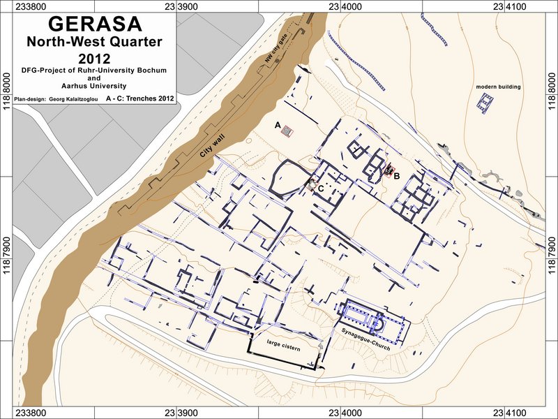
The main aim of the campaign was to begin to clarify the settlement history of the hill. Furthermore aims were to complete the topographic map begun in 2011 and to map the Northern part of the city wall within the investigation area in detail. Three trenches A–C (fig. 1) were laid out on top of the hill. These were chosen on the basis of the results of the 2011 campaign. Trench A, which was located on the highest point of the hill, was laid out to clarify an L-shaped geomagnetic anomaly detected in 2011. Trenches B and C were located in areas where undocumented activity had already taken place. Trench B was chosen because strong walls and a monumental architectural element were already visible on the surface. Trench C was laid out in order to investigate the most prominent visible building structure on top of the hill, the so-called ‘Ionic building’.
In total app. 95 m² were excavated until bedrock or the oldest structures was reached. It was an objective to reach bedrock or virgin soil without disturbing any relevant ancient structures. All trenches were backfilled. The relative chronology of the trenches was reconstructed, but in most cases an absolute dating of the various features will be subject to further ceramic and find studies. The major part of the finds point to a Byzantine and later date, whereas a smaller amount of finds can be related to earlier periods. A representative part of the finds from the 2012 campaign is forthcoming in ADAJ 2013 (Lichtenberger, Raja and Sørensen).
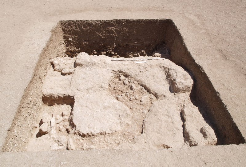
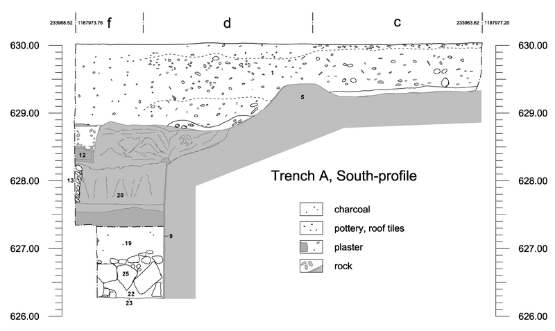
One objective of the 2012 campaign was to clarify an L-shaped anomaly on the highest place in the Northwest quarter near the ancient city wall, which the geomagnetic prospection of the 2011 campaign had revealed. Therefore trench A, measuring 5 x 5 meters and later extended by 1 meter towards the East, was opened above the anomaly. Today the area is used as a football pitch (fig. 2).
The geomagnetic anomaly turned out to reflect soil that was lying up against curving bedrock in the eastern-most part of the trench. The most important feature in trench A is the discovery of a rectangular room about 1.5 m under the surface which was cut c. 2.5 m deep into the bedrock. A niche (ev. 12) was uncovered in the top southeast corner of the room. Furthermore an installation on the floor consisting of two limestone blocks (ev. 24) was unearthed. Apart from these structures no other features were recorded in relation to the plastered bedrock (ev. 9) or floor (ev. 23). The inner face of the room shows one phase of plaster revetment only, which indicates that at least the room’s architectural design is of a single phase. For some reason the room was filled up with various deposition layers which contained some intentionally deposited finds. The surface of the bedrock (ev. 2, ev. 5) that nearly covers the whole area of trench A has chisel marks in several places indicating that this area was used as a quarry before building activities started.
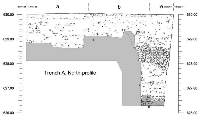
The soil stratigraphy is comprised of two main soil stratigraphic units; modern backfill layers (ev. 1, ev. 3, ev. 4 and parts of ev. 6) and ancient intentional fill layers (ev. 6, ev. 7, ev. 8, ev. 10, ev. 13, ev. 16, ev. 19, ev. 22 and ev. 25). The entire trench has been covered by a modern fill about 0.20 m to 1.70 m thick (fig. 3 and 4). The modern backfill relating to a leveling of the area mostly consisted of a clayish soil which held material spanning from the Neolithic period to the early Islamic period. The material of the modern backfill does not necessarily come from the hill top or the vicinity and thus gives no reliable indications for the ancient settlement history in this particular spot.
The ancient stratified fill layers hold material, which provide information about the last phase of the structure. Although some dense stone clusters were encountered, the ancient fill layers show little internal stratification suggesting a rapid infilling.

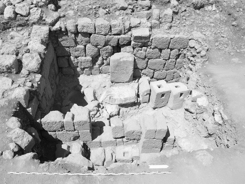
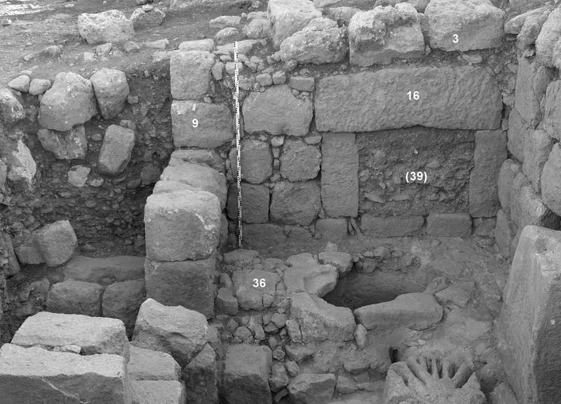
The trench was excavated at the eastern slope of the hill, east of a probably Mamluk house (see fig. 1). This house consists of two rooms and was erected on an older terrace (Fig. 5 and 6). Former undocumented excavation activities left a semicircular pit in front of this retaining wall which partly rests on bedrock. The excavated earth of the undocumented activities shows, that the whole area east in front of the terrace was filled with ancient debris. It contains a large amount of pottery, ashy soil and large stones. Due to modern finds it is possible to reconstruct at least two undocumented excavations: the first one in the year 1983, based on a juice carton with this expiry date and the second one during the years of 1994 till 1996, due to the expiry dates of two crisps bags. As a result of these undocumented activities ev. 2, 7, 12, 22, 25 and 28 were contaminated with Mamluk material.
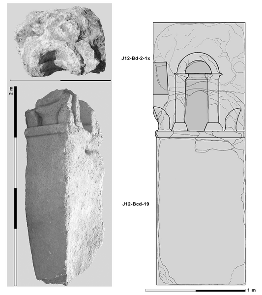
Already in 2011 a huge architectural block was seen partly uncovered at the surface (J12-Bcd-19). On two sides it showed an altar-relief. A second block (J12-Bd-2-1x) was found in addition to the architectural stone inside the excavated earth of the undocumented excavations. This block fitted on top of the large block. Together with the retaining wall the discovery of the two architectural pieces was the decisive reason to dispose the trench at this spot (for the architectural element see below).
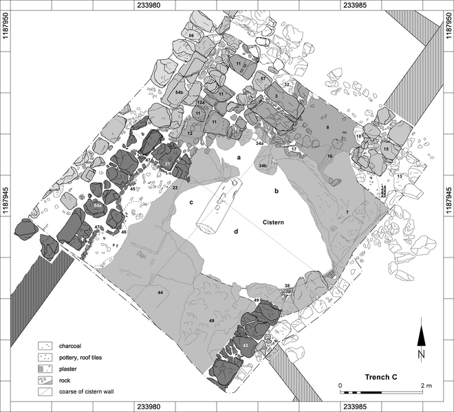
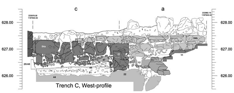
The most prominent building on top of the hill of the Northwest quarter is the so called ‘Ionic building’. It is a large courtyard house integrated in the local terrace system and showing signs of a series of repairs and alterations, which took place in the Early Islamic to Mamluk periods (fig. 1). The trench was laid out in the south-western corner of this building (Fig. 7). The rectangular outline of the excavated area measures approx. 6.50 x 6.50 m each side. To the north the level raises ca. 1.00 m towards the inner parts of the building and to the south it slopes, creating an altitude difference within this area of 1.15 m from north to south before the beginning of the excavation (Fig. 8). The area was disturbed in recent times, since to the south of the trench many stones of various sizes were found and the east-west-orientated southern wall of the large building could not be traced in the trench where it was supposed to have been situated. The fill in most parts of the trench consisted of stones of different sizes, some of them dressed as blocks. On top of this fill, almost in the middle of the trench, an Ionic capital of limestone was already recorded in the 2011 campaign (cat. no. 166). On closer examination, the capital revealed to have been exposed to fire.
Excavation in this area disclosed various structures which shed light on the history of the uppermost part of the walled city of Jerash at least from Byzantine/Early Islamic times to the Mamluk period. Especially in the northern and western sections of the trench several built structures which overlay each other were discovered. However, the oldest traces in the area are chisel-marks and -channels on top of the bedrock in the south-western (ev. 44) and north-eastern (ev. 7) part of the excavated area, proving that the spot was used as quarry before building activities started. The remaining traces indicate that almost square blocks of app. 0.50 to 0.60 m were broken down in this spot. Bedrock was discovered in the southern (ev. 44), western (ev. 22), and northern (ev. 7) part of the trench. It was found to be part of a more than semi-circular natural structure which forms a karst-cave to the north of which the eastern ceiling partly collapsed in later times. Especially in its southern and south-western parts the bedrock was worked off and roughly dressed in order to function as a cistern, which was revealed in the centre of the area. Most of the unearthed structures are related to this cistern and therefore their description and interpretation must emanate from the cistern itself. Beside the quarry, only the southern structures in the trench are older than the initial construction of the cistern.
The three trenches excavated during the 2012 campaign yielded little evidence for occupation prior to the Late Roman/Byzantine period. Most until now documented building activity took place between the Byzantine and early Islamic periods with some reoccupations in the middle Islamic period.
The earliest traces of human activities are the quarries in trenches A and C. They predate the later building activities and might be an indication of a sparsely settled area during the Roman period. However, the hill might have been occupied also in Roman and earlier periods as attested by sparse finds of pottery dating to the Hellenistic and Roman periods. Furthermore the monumental altar-shaped architectural element, which was reused in an oil press, probably relates to an earlier period (Fig. 9). However, it remains unsure whether this block had its original place of origin in the vicinity. At some point in the settlement history of the Northwest quarter a system of terraces was laid out in order to accommodate dense habitation, which covers the entire hill slopes. Even the oldest structures in the terraced area excavated so far follow the alignment of this system. As is evident by the overall mapping in general and in trenches B and C in particular some alterations of the inner arrangement took place over time.
The most prominent feature excavated in the 2012 campaign was a well preserved oil press in trench B (Figs. 7, 8 and 10). At least in some parts of the Northwest quarter, such as around trench B, the extensive fill with destruction debris in Late Byzantine or as in Trench C in Early Islamic times put an end to the settlement history.
Until the Middle Islamic period the excavated areas seem to have been more or less abandoned. From this period building activity begun again and the large courtyard house over the cistern in trench C was constructed. Smaller and simple houses were also erected. Repairs and modifications of the buildings prove that the occupants, who had Mamluk style pottery, lived in this area at least over a period of some generations.
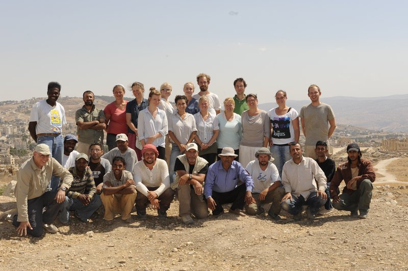
The team consisted of the two directors Achim Lichtenberger and Rubina Raja, head of the field team Georg Kalaitzoglou, head of the registration team Annette H. Sørensen, architect Jens C. Pinborg, conservator Helle Strehle, photographer Michael Benecke and the field and registration team: Dorothea Csitneki, Christoffer P. Hagelquist, Ditte M. D. Hiort, Signe B. Koch, Signe Krag, Signe B. Kristensen, Cathrin Pogoda, Eicke Granser, Anne Riedel and Stefan Riedel.