
Surviving in the Desert: Could Roman Palmyra feed itself?
By Research Assistant Joan Campmany Jiménez.


In early November, the Circular Economy and Urban Sustainability in Antiquity Project started looking into demographic patterns in ancient Palmyra. The team is directed by Professor Dr. Rubina Raja, working together with Assistant Professor Dr. Olympia Bobou and AIAS-COFUND Fellow Dr. Iza Romanowska, as well as Dr. Julia Steding and MSt. Joan Campmany Jiménez as Research Assistants. The project is funded through grants by the Augustinus Foundation and the Carlsberg Foundation. Through the comparison of several different datasets, the team aims to establish demographic trends in Palmyra. It is in the context of these demographic shifts that the Palmyrene circular economy took place, and therefore understanding them is critical.
An important element in understanding population changes is the carrying capacity of the territory surrounding Palmyra. Any population exceeding the carrying capacity must have been sustained by importing food. To establish the carrying capacity of the territory, we must consider three factors. First, the time it takes to move from any point in the city’s surroundings to the city itself. Food produced too far away from the city centre could not have been brought in by the producers themselves, it would have been either consumed locally or sold. We should therefore establish the area that could reach the city within a specific time. Secondly, not all soil types are equally productive, making some areas more suitable to agricultural activity than others. This is especially relevant for Palmyra, due to its location at the edge of the Syrian Desert. Finally, we must account for climatic changes affecting food production. They might have had an impact on Palmyra’s ability to sustain its population thus forcing greater focus on trade.
So far, we have focused on determining the productive area that could be reached from Palmyra in reasonable time. This can be learnt using GIS, through the well-known process of cost analysis. By processing a Digital Elevation Model (DEM), we can generate a Slope map, which in turn can be transformed into a friction map. We have used the GMTED2010 7.5 arc-second mean elevation map for the area of Syria, courtesy of the US Geological Survey, reprojected in UTM coordinates and modified to have regularly sized cells. Once processed into a suitable Slope raster, we have generated a Friction map. For this, we have used an adapted form of Tobler’s Hiking Function (Tobler 1993; modified formula taken from White 2015), designed to give an output in hours, to account for the map resolution and to employ degrees as the slope unit. The result is a new map, where each cell contains a value, equivalent to the time in hours it would take to cross that particular cell.
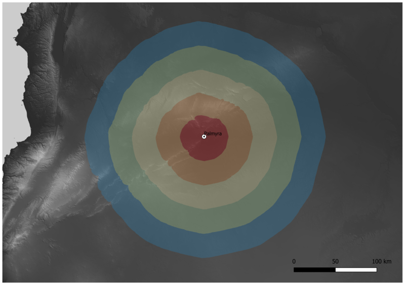
With this friction surface, we can then execute an accumulated cost calculation. This function calculates the minimum cost (in hours) and direction of movement from any given cell in the map towards a specific source point, in our case, Palmyra. The location of the city we got from OXREP´s cities database (Hanson 2016).
According to the resulting map (Figure 1), the relief around Palmyra does not impede movement significantly in all directions. It is not until the coastal Mountain Ranges are reached that movement is seriously affected by the topography of the terrain. However, this is not a realistic expectation of movement velocity. Firstly, the function assumes ideal conditions. However not all terrains are equally suited to human mobility. In the case of Palmyra’s surroundings, the arid landscape makes water availability the main concern regarding movement. Therefore, if we aim to have a more realistic cost envelope, we need to account for the presence or absence of water sources. The way to do this is to distort the friction value of each cell according to the presence or absence of a water source in its vicinity. In this case, we assigned different reliability values to different types of water sources (water sources from Seland 2019). By generating an area around each source where cost is lower than in the surrounding areas, we can better approach the actual cost of moving across the desert.
The second map (Figure 2) shows a much more nuanced cost calculation. The areas closer to water sources are shown to be less costly to traverse. And in fact, the lower cost areas seem to land quite close to the main routes between the Mediterranean and the Persian Gulf in the area surrounding Palmyra as described by Seland (2018) (Figure 3). Another interesting and visible characteristic of this model is that water availability does not seem to be a concern when traveling Northwest and North from Palmyra, or at least not as it is in all other directions, since water is much more plentiful there.
This model is, however, very clearly a work in progress, and many of the parameters need to be tested further. For example, the intervals are ten times larger than in the second map, because the cost distortion is so strong that the accumulated cost is unrealistically high. More work is still necessary to refine this model to allow us to better establish the approximate area that could have directly supplied Palmyra. However, these are the first steps in that direction.
More about this project is available at https://projects.au.dk/circulareconomy/
Augustinus Foundation: https://augustinusfonden.dk/
Carlsberg Foundation: https://www.carlsbergfondet.dk/en
References
- Hanson, J. W. (2016). An Urban Geography of the Roman World, 100 BC to AD 300 (Vol. 18). Archaeopress Oxford.
- Seland, E. H. (2018). Nomads and Caravan Trade in the Syrian Desert. In N. Boivin & M. Frachetti (Eds.), Globalization in Prehistory: Contact, Exchange and the “People Without History” (pp. 184–204). Cambridge University Press. doi:10.1017/9781108573276.009
- Seland, E. H. (2019). Water sources in the Syrian Desert (University of Bergen, Ed.; V2 ed.). DataverseNO. doi.org/10.18710/CEY9QR
- Tobler, W. (1993). Three Presentations on Geographical Analysis and Modeling (Technical Report No. 93–1). National Center for Geographic Information and Analysis.
- White, D. A. (2015). The Basics of Least Cost Analysis for Archaeological Applications. Advances in Archaeological Practice, 3(4), 407–414. Cambridge Core. doi.org/10.7183/2326-3768.3.4.407
Data Sources
- Hanson, J. W. (2016). Cities Database (OXREP databases) Version 1.0. Accessed 6th November 2020. oxrep.classics.ox.ac.uk/databases/cities/; DOI: doi.org/10.5287/bodleian:eqapevAn8
- Seland, E. H. (2019). Water sources in the Syrian Desert. Accessed 6th November 2020. DataverseNO. doi.org/10.18710/CEY9QR
- US Geographic Survey. (2011). USGS EROS Archive—Digital Elevation—Global Multi-resolution Terrain Elevation Data 2010 (GMTED2010). Accessed 5th November 2020. USGS. doi.org/10.5066/F7J38R2N
Further Reading
- Meyer, J. C., & Seland, E. H. (2016). Palmyra and the Trade Route to the Euphrates. Hatra, Palmyra and Edessa. Cultural Exchanges between Cities in the Fertile Crescent before Islam, 28, 1–2, 497–523.