
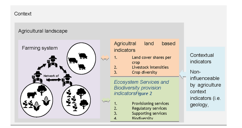
Characterizing mixed farming system from a landscape perspective
Mixed farming and agroforestry plays out at different levels such as fields, landscapes or regions. The complex interaction between farms in a landscape within a specific context may result in impacts that differs from what can be measured at farm level. Therefore, it is relevant to explore impacts of mixed systems also at landscape level.


Catherine Pfeifer, Linn Schaan and Florian Hediger from FiBL recently explored mixed farming systems at the landscape scale with the objective to identify priority areas for mixed farming systems.
As a first step, they developed a conceptual framework rooted in landscape ecology - a framework that recognizes networks of farms within a landscape as co-creaters of agricultural landscapes. Farmers’ decisions about agricultural activities are influenced by the biophysical context such as climate, soil type or slope - but the agricultural activities also influence and change the landscape, for example by setting up an agroforestry scheme.
The researchers agricultural activities were assessed in terms of land cover share of each crop, including perennial crops within a landscape, as well as livestock intensities per species.
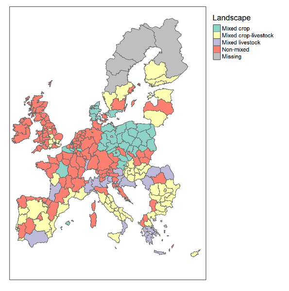
With a so-called latent profile analysis, a clustering technique emanating from mixtures models, they identified different classes of landscape, that can be assumed similar in terms of farming activities, i.e. with similar crop and livestock combinations. They found that Europe could be grouped into 19 classes of landscapes (see fig. 2).
A decision tree was developed to characterize the different landscapes, based on which crops and types of livestock was considered as dominant. The landscapes were also classified according to livestock intensity.
Furthermore, landscapes where classified as 'mixed' based on a Shannon weaver index as follows:
- Mixed cropping landscapes have a high diversity of cropping activities observed,
- Mixed livestock landscapes have a high diversity of livestock activities observed at the landscape scale, and
- Mixed crop-livestock landscapes where a high diversity of crop or livestock activities is combined with a relatively important diversity of the other type of activities.
This resulted in the attached description of the identified landscape classes 1-18.
The 18 landscape classes are grouped in 4 categories: mixed crop landscapes, mixed livestock landscapes, mixed crop-livestock landscapes and non-mixed landscapes.Using these categories the map in figure 2 can be simplified as illustrated in figure 3.
The next step in the exploration of priority areas for mixed farming systems will be to validate the landscape classifications together with stakeholders. Once a final set of mixed agricultural landscapes is defined in the MIXED project the researchers will explore in which context mixed agricultural landscapes have emerged. To do this they will create similarity maps, to identify locations that are today considered non-mixed, yet are situated in a context that is similar to a specific mixed landscape. Additionally, they will explore which types of mixed landscapes have emerged from mixed farms and which have emerged from a network of specialised farms.