
The Chora of Gerasa/Jerash
New publication by Professor Achim Lichtenberger (Westfälische Wilhelms-Universität Münster) and Professor Rubina Raja.
Lichtenberger, A. & Raja, R. (2019). ”The Chora of Gerasa/Jerash”, in: A. Lichtenberger, O. Tal & Z. Weiss (eds), Judaea/Palaestina and Arabia: Cities and Hinterlands in Roman and Byzantine Times: Panel 8.6. Archaeology and Economy in the Ancient World – Proceedings of the 19. International Congress of Classical Archaeology, Cologne/Bonn 2018, Band 4, Heidelberg, 109-124.
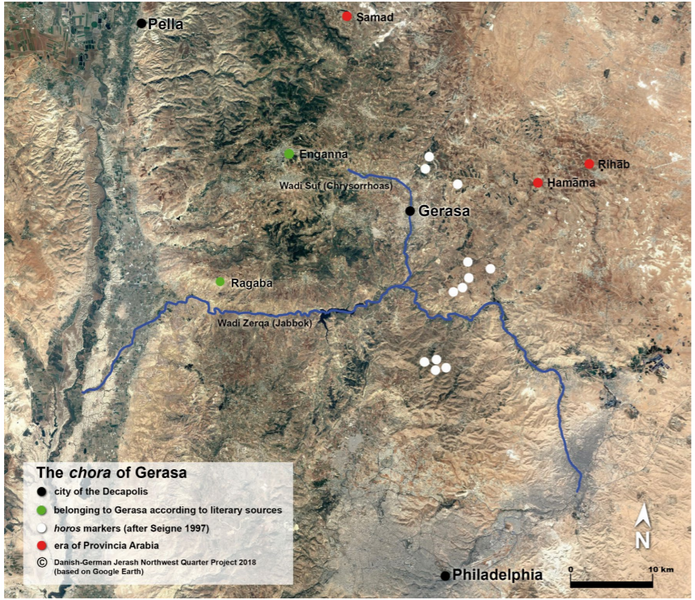
The city of Gerasa is situated in the fertile hill country of northwestern Jordan. It was founded in the 2nd century BCE, as “Antioch on the Chrysorrhoas, the former Gerasa” and flourished in the Roman, Byzantine and Early Islamic periods until it was destroyed by an earthquake in 749 CE. Subsequently the city was largely abandoned and reduced immensely in scale.
Gerasa belonged to the Decapolis, a term of the Roman period, covering nominally only a group of cities located in what today is modern day southern Syria, Jordan and Israel. These cities displayed profound Greco-Roman urban layouts and were modelled on the Greek polis model. The poleis of the Decapolis – as other Roman cities in the Greek east – had autonomous administrations with civic institutions and a territory (chora) with clearly marked boundaries. In this publication, the excavation directors of the Danish-German Jerash Northwest Quarter Project deal with the chora of Gerasa/Jerash.