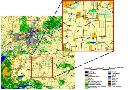
The landscape model is at the heart of ALMaSS. The model can handle a landscape maps up to 50x50km, but typically we use 10 x 10 km areas. The model, with a 1-m resolution, provides detailed structures such as field boundaries, to be represented even at a map size of 10 x 10 km. The detail is one of the characteristics that sets ALMaSS apart from other models, it is also necessary to allow the realistic simulation of the behaviour of the range of species modelled.
The landscape model provides the data for the animal models as well as providing one way in which model scenarios can be generated. The landscape model is a dynamic structure, with a weather simulator, a road-traffic simulator, and simulated farm management. Learn more about ALMaSS Landscape and associated classes in the MIDox documentation.

ALMaSS landscape modelling started in Denmark in but has now been expanded to include 12 European countries. These expansions have been made possible by research funding from national funds and Horizon 2020 projects.
In ALMaSS, landscapes are modelled using a detailed, spatio-temporal representation that provides a realistic environment for agent-based simulations of the focal species. In this representation:
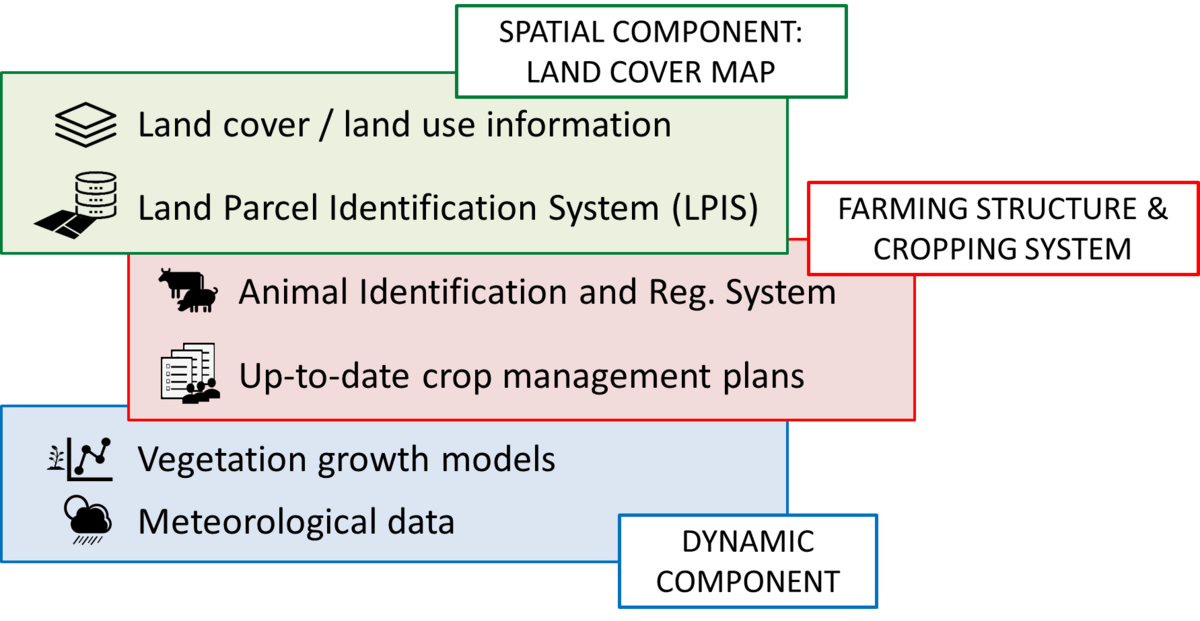
- Spatial landscape heterogeneity is described by a detailed raster land cover map with complete coverage and spatial resolution of 1 m<font size="2">2</font>. Each unit in the raster land cover map is classified in accordance with its landscape element type (e.g., natural or permanent grassland, field in rotation, build-up area), including detailed structures important for the species under consideration, such as hedgerows or field margins. To account for crop diversity, field boundaries are also added, with each field belonging to a given farm unit (managed by the same farmer). Farm units are classified into different types, e.g., cattle, pig or arable farms, based on structure of crops grown and animals present in the farm. This structure allows to incorporate information on farm management to the description of spatial heterogeneity in a given point of time (Topping et al. 2003, 2016).
- Temporal landscape heterogeneity includes both crop management throughout a year, described through individually tailored management plans for each crop, and the cropping system understood as a pluriannual crop rotation. Associated vegetation growth models for all modelled vegetation types and crops supply vegetation height, green and total, biomass on a daily basis and are fed by weather conditions (mean daily temperature, mean daily wind speed and daily sum of precipitation)
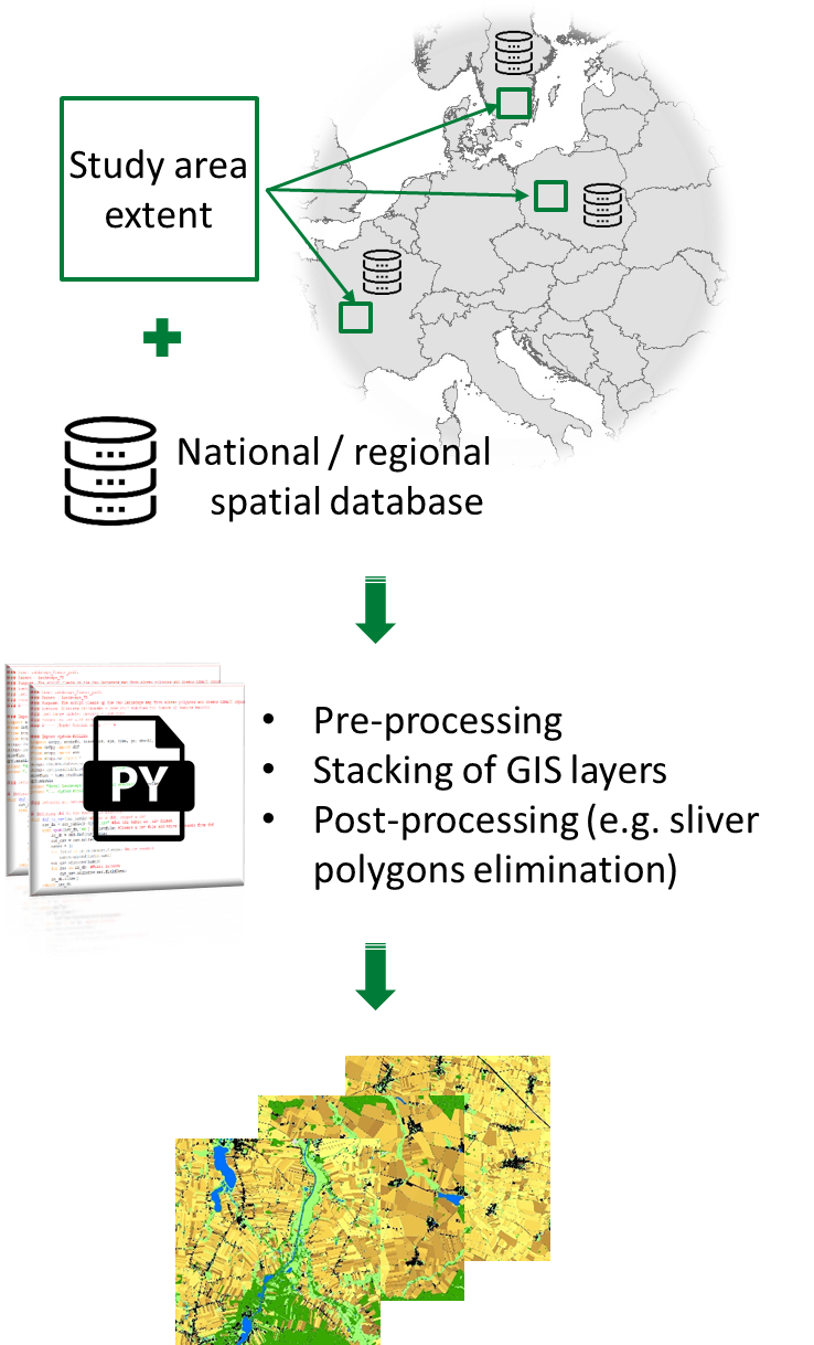
The generation of ALMaSS landscape models can be divided into the following sub-tasks:
The first task is to collect the main types of data that will form the map and the basis for simulating the agricultural management in ALMaSS.
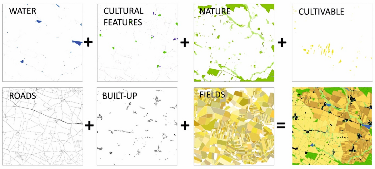
Individual layers of land use / land cover information together with information on agricultural fields are combined into a single raster landscape map in a step-by-step process, followed up by procedure removing inconsistencies related to spatial alignment of features (overlaps or gaps between features) or pre-processed of point and line features into two-dimensional ones.
Inside the model landscape, all vegetation types and crops have their own seasonal growth models supplying vegetation height, green and total, biomass.
The result is a dynamic landscape with all vegetation growing in response to the weather. Crops and other vegetation also respond to management. Crops will grow from sowing and respond to management events such as harvest and cutting. Non-crop vegetation can also be managed, e.g. roadside verges are mown during summer in the model.
A description of the implementation of vegetation growth models in ALMaSS can be found here.
Once all the data is assembled it needs to be combined to create the working ALMaSS landscape. This is done through he creation of scripts to manipulate the data. The precise conditions and data structure differ for each country, hence the basic script is modified for each specific case. Once complete the script can be used to auto-generate a working ALMaSS landscape from any area covered by the data sets for that country. For most countries this is national, but for some e.g. France and Germany this process needs to be carried out for each state/region. Only Portugal does not have this regional/national coverage due to the high costs of purchase of the geographic data in this country.